

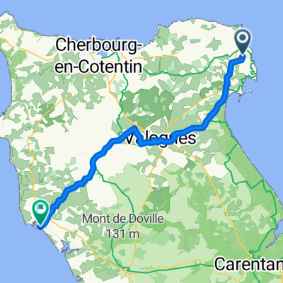
Route du Val de Saire 5135A nach PM28+RP
A cycling route starting in Réville, Normandy, France.
Overview
About this route
- 41 min
- Duration
- 9.4 km
- Distance
- 10 m
- Ascent
- 8 m
- Descent
- 13.8 km/h
- Avg. speed
- 5 m
- Max. altitude
Route quality
Waytypes & surfaces along the route
Waytypes
Track
3.9 km
(41 %)
Quiet road
2.9 km
(31 %)
Surfaces
Paved
4.7 km
(50 %)
Unpaved
0.6 km
(6 %)
Asphalt
4.7 km
(50 %)
Unpaved (undefined)
0.3 km
(3 %)
Continue with Bikemap
Use, edit, or download this cycling route
You would like to ride Route du Val de Saire 5135A nach PM28+RP or customize it for your own trip? Here is what you can do with this Bikemap route:
Free features
- Save this route as favorite or in collections
- Copy & plan your own version of this route
- Sync your route with Garmin or Wahoo
Premium features
Free trial for 3 days, or one-time payment. More about Bikemap Premium.
- Navigate this route on iOS & Android
- Export a GPX / KML file of this route
- Create your custom printout (try it for free)
- Download this route for offline navigation
Discover more Premium features.
Get Bikemap PremiumFrom our community
Other popular routes starting in Réville
 20141025_CHATAIGNES
- Distance
- 36.6 km
- Ascent
- 459 m
- Descent
- 460 m
- Location
- Réville, Normandy, France
 Boucle Barfleur - La Brisette
- Distance
- 51.8 km
- Ascent
- 474 m
- Descent
- 474 m
- Location
- Réville, Normandy, France
 Route du Val de Saire 5135A nach PM28+RP
- Distance
- 9.4 km
- Ascent
- 10 m
- Descent
- 8 m
- Location
- Réville, Normandy, France
 jour 3 mod
- Distance
- 61.6 km
- Ascent
- 40 m
- Descent
- 38 m
- Location
- Réville, Normandy, France
 11–13 Quai Henri Chardon, Barfleur à 14 Résidence du Vieux Colombier, Saint-Vaast-la-Hougue
- Distance
- 14.1 km
- Ascent
- 38 m
- Descent
- 36 m
- Location
- Réville, Normandy, France
 50 Rue Saint-Thomas-Becket, Barfleur à 11 Quai Henri Chardon, Barfleur
- Distance
- 50 km
- Ascent
- 507 m
- Descent
- 507 m
- Location
- Réville, Normandy, France
 jour 3
- Distance
- 65.8 km
- Ascent
- 36 m
- Descent
- 41 m
- Location
- Réville, Normandy, France
 From Montfarville to Valognes
- Distance
- 63.3 km
- Ascent
- 677 m
- Descent
- 682 m
- Location
- Réville, Normandy, France
Open it in the app