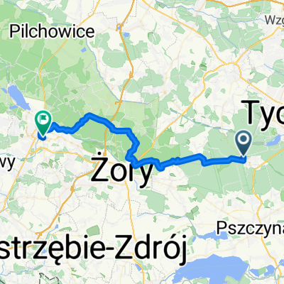
Leśników, Kobiór do Śląska, Katowice
A cycling route starting in Kobiór, Silesian Voivodeship, Poland.
Overview
About this route
- 2 h 48 min
- Duration
- 46.1 km
- Distance
- 258 m
- Ascent
- 228 m
- Descent
- 16.5 km/h
- Avg. speed
- 325 m
- Max. altitude
Route photos
Route quality
Waytypes & surfaces along the route
Waytypes
Quiet road
13.8 km
(30 %)
Road
13.7 km
(30 %)
Surfaces
Paved
17.9 km
(39 %)
Unpaved
9.8 km
(21 %)
Asphalt
15.4 km
(33 %)
Gravel
5.3 km
(12 %)
Continue with Bikemap
Use, edit, or download this cycling route
You would like to ride Leśników, Kobiór do Śląska, Katowice or customize it for your own trip? Here is what you can do with this Bikemap route:
Free features
- Save this route as favorite or in collections
- Copy & plan your own version of this route
- Sync your route with Garmin or Wahoo
Premium features
Free trial for 3 days, or one-time payment. More about Bikemap Premium.
- Navigate this route on iOS & Android
- Export a GPX / KML file of this route
- Create your custom printout (try it for free)
- Download this route for offline navigation
Discover more Premium features.
Get Bikemap PremiumFrom our community
Other popular routes starting in Kobiór
- Kobiór, Paprocany, Zgoń, Kobiór
- Distance
- 45.3 km
- Ascent
- 297 m
- Descent
- 295 m
- Location
- Kobiór, Silesian Voivodeship, Poland
- lasy pszczynskie
- Distance
- 42.8 km
- Ascent
- 155 m
- Descent
- 158 m
- Location
- Kobiór, Silesian Voivodeship, Poland
- Czarków do Goczałkowice-Zdrój, Goczałkowice-Zdrój
- Distance
- 15 km
- Ascent
- 131 m
- Descent
- 134 m
- Location
- Kobiór, Silesian Voivodeship, Poland
- GUSTAWÓW v MAR
- Distance
- 214.1 km
- Ascent
- 437 m
- Descent
- 415 m
- Location
- Kobiór, Silesian Voivodeship, Poland
- Tychy zmiany
- Distance
- 8.1 km
- Ascent
- 53 m
- Descent
- 45 m
- Location
- Kobiór, Silesian Voivodeship, Poland
- Rezerwat Dobrzyna Dolina
- Distance
- 27.9 km
- Ascent
- 111 m
- Descent
- 111 m
- Location
- Kobiór, Silesian Voivodeship, Poland
- Paprocany- Goczałkowickie- Żywieckie 67km km
- Distance
- 155 km
- Ascent
- 410 m
- Descent
- 388 m
- Location
- Kobiór, Silesian Voivodeship, Poland
- Kobiór - Opole
- Distance
- 123.4 km
- Ascent
- 233 m
- Descent
- 325 m
- Location
- Kobiór, Silesian Voivodeship, Poland
Open it in the app