
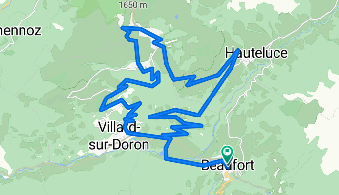
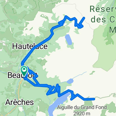
Day 3 - OPTIONAL Col des Saisies
A cycling route starting in Beaufort, Auvergne-Rhône-Alpes, France.
Overview
About this route
- 2 h 26 min
- Duration
- 35.8 km
- Distance
- 1,513 m
- Ascent
- 1,513 m
- Descent
- 14.7 km/h
- Avg. speed
- 1,666 m
- Max. altitude

Route quality
Waytypes & surfaces along the route
Waytypes
Quiet road
12.5 km
(35 %)
Track
3.6 km
(10 %)
Surfaces
Paved
28.3 km
(79 %)
Unpaved
3.2 km
(9 %)
Asphalt
28.3 km
(79 %)
Gravel
2.9 km
(8 %)
Continue with Bikemap
Use, edit, or download this cycling route
You would like to ride Day 3 - OPTIONAL Col des Saisies or customize it for your own trip? Here is what you can do with this Bikemap route:
Free features
- Save this route as favorite or in collections
- Copy & plan your own version of this route
- Sync your route with Garmin or Wahoo
Premium features
Free trial for 3 days, or one-time payment. More about Bikemap Premium.
- Navigate this route on iOS & Android
- Export a GPX / KML file of this route
- Create your custom printout (try it for free)
- Download this route for offline navigation
Discover more Premium features.
Get Bikemap PremiumFrom our community
Other popular routes starting in Beaufort
 col de la forclaz, col de aspartaz; col des saisies par crest voland
- Distance
- 84 km
- Ascent
- 2,376 m
- Descent
- 2,376 m
- Location
- Beaufort, Auvergne-Rhône-Alpes, France
 Cormet d'Areches and Col du Pré
- Distance
- 54.7 km
- Ascent
- 1,964 m
- Descent
- 1,964 m
- Location
- Beaufort, Auvergne-Rhône-Alpes, France
 Areches to Courmayer 95K 2850M
- Distance
- 94 km
- Ascent
- 2,726 m
- Descent
- 2,507 m
- Location
- Beaufort, Auvergne-Rhône-Alpes, France
 beaufortain
- Distance
- 1.7 km
- Ascent
- 147 m
- Descent
- 15 m
- Location
- Beaufort, Auvergne-Rhône-Alpes, France
 Francia Alpok 16 vándor
- Distance
- 110.2 km
- Ascent
- 1,534 m
- Descent
- 2,814 m
- Location
- Beaufort, Auvergne-Rhône-Alpes, France
 Day 4 - Col des Arvaris then Col de la Croix Fry
- Distance
- 65.9 km
- Ascent
- 2,834 m
- Descent
- 2,835 m
- Location
- Beaufort, Auvergne-Rhône-Alpes, France
 (08) Beaufort - Bourg-St.Maurice
- Distance
- 43.4 km
- Ascent
- 1,330 m
- Descent
- 1,197 m
- Location
- Beaufort, Auvergne-Rhône-Alpes, France
 Day 2 - Col Du Joly, Cormet de Roselend
- Distance
- 81.7 km
- Ascent
- 3,903 m
- Descent
- 3,903 m
- Location
- Beaufort, Auvergne-Rhône-Alpes, France
Open it in the app