

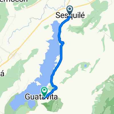
Primera Etapa – CRI
A cycling route starting in Sesquilé, Cundinamarca, Colombia.
Overview
About this route
<div id="yui_3_2_0_21_1341096649371608" class="yiv2075436823MsoNormal" style="margin: 0cm 0cm 0.0001pt; font-size: 11pt; font-family: sans-serif; color: #000000;"><span id="yui_3_2_0_21_1341096649371610" style="font-size: 12pt;">Recorrido: Sesquilé – Guatavita</span></div> <div id="yui_3_2_0_21_1341096649371472" class="yiv2075436823MsoNormal" style="margin: 0cm 0cm 0.0001pt; font-size: 11pt; font-family: sans-serif; color: #000000;"><span id="yui_3_2_0_21_1341096649371471" style="font-size: 12pt;">Distancia: 16Km <span id="lw_1341096964_14" class="yshortcuts cs4-visible" style="cursor: pointer; color: #366388; border-bottom-width: 2px; border-bottom-style: dotted; border-bottom-color: #366388;">aprox</span></span></div>
- -:--
- Duration
- 15.5 km
- Distance
- 280 m
- Ascent
- 190 m
- Descent
- ---
- Avg. speed
- ---
- Max. altitude

Route quality
Waytypes & surfaces along the route
Waytypes
Busy road
13.5 km
(87 %)
Quiet road
0.7 km
(5 %)
Surfaces
Paved
13.5 km
(87 %)
Asphalt
13.5 km
(87 %)
Undefined
2 km
(13 %)
Continue with Bikemap
Use, edit, or download this cycling route
You would like to ride Primera Etapa – CRI or customize it for your own trip? Here is what you can do with this Bikemap route:
Free features
- Save this route as favorite or in collections
- Copy & plan your own version of this route
- Sync your route with Garmin or Wahoo
Premium features
Free trial for 3 days, or one-time payment. More about Bikemap Premium.
- Navigate this route on iOS & Android
- Export a GPX / KML file of this route
- Create your custom printout (try it for free)
- Download this route for offline navigation
Discover more Premium features.
Get Bikemap PremiumFrom our community
Other popular routes starting in Sesquilé
 CARAJILLO - PTE DE BOYACA- SAMACA -VILLA DE LEYVA
- Distance
- 111.6 km
- Ascent
- 1,134 m
- Descent
- 1,554 m
- Location
- Sesquilé, Cundinamarca, Colombia
 De Carrera 6 51, Sesquilé a Carrera 1 5-2, Guatavita
- Distance
- 15.2 km
- Ascent
- 364 m
- Descent
- 236 m
- Location
- Sesquilé, Cundinamarca, Colombia
 De Bogotá - Tunja a Carrera 7 634, Sesquilé
- Distance
- 5.7 km
- Ascent
- 27 m
- Descent
- 81 m
- Location
- Sesquilé, Cundinamarca, Colombia
 Gachancipa - Guatavita - Alto de la Cuchilla
- Distance
- 73.6 km
- Ascent
- 1,734 m
- Descent
- 947 m
- Location
- Sesquilé, Cundinamarca, Colombia
 Primera Etapa – CRI
- Distance
- 15.5 km
- Ascent
- 280 m
- Descent
- 190 m
- Location
- Sesquilé, Cundinamarca, Colombia
 De Carrera 6 51, Sesquilé a Carrera 1 5-2, Guatavita
- Distance
- 15.5 km
- Ascent
- 412 m
- Descent
- 288 m
- Location
- Sesquilé, Cundinamarca, Colombia
 las rutas
- Distance
- 32.3 km
- Ascent
- 193 m
- Descent
- 208 m
- Location
- Sesquilé, Cundinamarca, Colombia
 De Guatavita - Sesquile a Carrera 5 7-7, Guatavita
- Distance
- 15.8 km
- Ascent
- 279 m
- Descent
- 152 m
- Location
- Sesquilé, Cundinamarca, Colombia
Open it in the app