

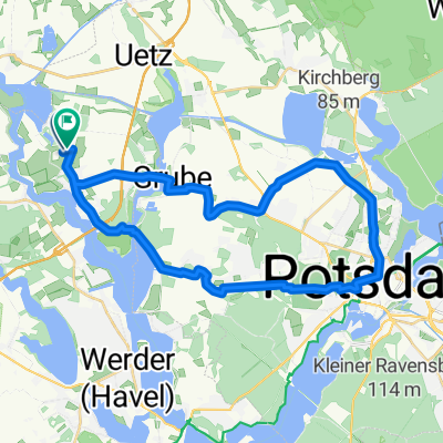
Route zu Golm Bahnhof
A cycling route starting in Ketzin, Brandenburg, Germany.
Overview
About this route
On this route, you can experience the diverse landscape in and around the island of Töplitz. Surrounded by the Havel River, lakes, and the Sacrow-Paretzer Canal, the route offers varied views of vast fields, swamp forests, diverse riverbank landscapes, and old villages such as Grube, Leest, Göttin, Alt-Töplitz, and Golm. The island is used agriculturally in a variety of ways, and since 2007, vineyards have been cultivated there again. Today it belongs to the municipality of Werder/Havel and was owned by the Lehnin Monastery for many centuries.
- 1 h 35 min
- Duration
- 23 km
- Distance
- 72 m
- Ascent
- 77 m
- Descent
- 14.6 km/h
- Avg. speed
- 59 m
- Max. altitude

Route photos


Route quality
Waytypes & surfaces along the route
Waytypes
Quiet road
10.1 km
(44 %)
Track
6 km
(26 %)
Surfaces
Paved
14.3 km
(62 %)
Unpaved
4.1 km
(18 %)
Asphalt
8.1 km
(35 %)
Concrete
4.1 km
(18 %)
Continue with Bikemap
Use, edit, or download this cycling route
You would like to ride Route zu Golm Bahnhof or customize it for your own trip? Here is what you can do with this Bikemap route:
Free features
- Save this route as favorite or in collections
- Copy & plan your own version of this route
- Sync your route with Garmin or Wahoo
Premium features
Free trial for 3 days, or one-time payment. More about Bikemap Premium.
- Navigate this route on iOS & Android
- Export a GPX / KML file of this route
- Create your custom printout (try it for free)
- Download this route for offline navigation
Discover more Premium features.
Get Bikemap PremiumFrom our community
Other popular routes starting in Ketzin
- Route zu Golm Bahnhof
- Distance
- 23 km
- Ascent
- 72 m
- Descent
- 77 m
- Location
- Ketzin, Brandenburg, Germany
 Töplitz 33km new
- Distance
- 32 km
- Ascent
- 95 m
- Descent
- 97 m
- Location
- Ketzin, Brandenburg, Germany
 Brückenkopf
- Distance
- 8.9 km
- Ascent
- 13 m
- Descent
- 13 m
- Location
- Ketzin, Brandenburg, Germany
 0000A mit Cecilienhof
- Distance
- 33.3 km
- Ascent
- 106 m
- Descent
- 106 m
- Location
- Ketzin, Brandenburg, Germany
 Von Groß Kreutz (Havel) bis Ketzin/Havel
- Distance
- 58.9 km
- Ascent
- 117 m
- Descent
- 113 m
- Location
- Ketzin, Brandenburg, Germany
 Töplitz 31km
- Distance
- 31.3 km
- Ascent
- 111 m
- Descent
- 113 m
- Location
- Ketzin, Brandenburg, Germany
 0000B ohne Cecilienhof
- Distance
- 32 km
- Ascent
- 95 m
- Descent
- 97 m
- Location
- Ketzin, Brandenburg, Germany
 Ketzin - Werder/Havel
- Distance
- 18.2 km
- Ascent
- 45 m
- Descent
- 43 m
- Location
- Ketzin, Brandenburg, Germany
Open it in the app