

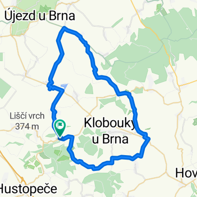
Šit. - Mout. - Nes. - Těš. - Šit.
A cycling route starting in Šitbořice, South Moravian, Czechia.
Overview
About this route
The more information you write here, the more useful it will be for other users.
- Route details.
- What is special about this route?
- Why recommend this route?
- What did you like the most here?
- Etc.
- -:--
- Duration
- 19.2 km
- Distance
- 106 m
- Ascent
- 106 m
- Descent
- ---
- Avg. speed
- ---
- Max. altitude

Route quality
Waytypes & surfaces along the route
Waytypes
Road
9.6 km
(50 %)
Quiet road
2.9 km
(15 %)
Surfaces
Paved
12.9 km
(67 %)
Unpaved
1.5 km
(8 %)
Asphalt
9.6 km
(50 %)
Paved (undefined)
3.3 km
(17 %)
Continue with Bikemap
Use, edit, or download this cycling route
You would like to ride Šit. - Mout. - Nes. - Těš. - Šit. or customize it for your own trip? Here is what you can do with this Bikemap route:
Free features
- Save this route as favorite or in collections
- Copy & plan your own version of this route
- Sync your route with Garmin or Wahoo
Premium features
Free trial for 3 days, or one-time payment. More about Bikemap Premium.
- Navigate this route on iOS & Android
- Export a GPX / KML file of this route
- Create your custom printout (try it for free)
- Download this route for offline navigation
Discover more Premium features.
Get Bikemap PremiumFrom our community
Other popular routes starting in Šitbořice
 bike 9.3.2011 (schwinn)
- Distance
- 31.9 km
- Ascent
- 371 m
- Descent
- 374 m
- Location
- Šitbořice, South Moravian, Czechia
 Author Brněnsko 2025-07-17_Diváky-Bošovice
- Distance
- 48.5 km
- Ascent
- 0 m
- Descent
- 0 m
- Location
- Šitbořice, South Moravian, Czechia
 Ždánický les - k rybníku Horáček
- Distance
- 31 km
- Ascent
- 368 m
- Descent
- 367 m
- Location
- Šitbořice, South Moravian, Czechia
 Velký severozápadní okruh
- Distance
- 59.8 km
- Ascent
- 241 m
- Descent
- 241 m
- Location
- Šitbořice, South Moravian, Czechia
 Šit. - Mout. - Nes. - Těš. - Šit.
- Distance
- 19.2 km
- Ascent
- 106 m
- Descent
- 106 m
- Location
- Šitbořice, South Moravian, Czechia
 První 2013
- Distance
- 12.7 km
- Ascent
- 180 m
- Descent
- 180 m
- Location
- Šitbořice, South Moravian, Czechia
 Bořetice I
- Distance
- 37.1 km
- Ascent
- 579 m
- Descent
- 579 m
- Location
- Šitbořice, South Moravian, Czechia
 Cesta na Mohylu
- Distance
- 40.4 km
- Ascent
- 340 m
- Descent
- 340 m
- Location
- Šitbořice, South Moravian, Czechia
Open it in the app