
Marlinton-Cloverlick Loop
A cycling route starting in Marlinton, West Virginia, United States.
Overview
About this route
This is a great loop with a variety of riding challenges. The first part is on narrow country roads with plenty of ups and downs and many short steep climbs. The last half will be in two lane roads and overall downhill for fast cruising back into Marlington. The last 6 miles from Huntersville to Marlinton is usually the only section where you run into any traffic issues.
I usually start this ride in Edray do to camping nearby but will do the turn list from downtown Marlinton. You can get water at the picnic area or office of Seneca state forest.
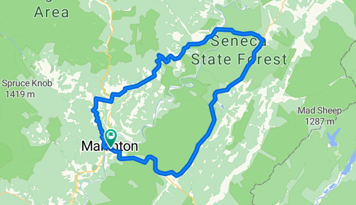
0.0 Downtown Marlinton at Greenbrier River Trail crossing.
0.3 Left on the Rt. 39 at end of bridge.
0.5 Right on Jericho Road<br />
4.3 Left - Bare left to continue on Jericho Rd.
4.9 Right on Co. Rt. 17 Woodrow Road
6.0 Left on Rt 219 at Edray. Last store on the route.
6.2 Right on Back Mt. Road past the church. Continue on Back Mt. Road till Cloverlick.<br />
11.8 The Loop
16.7 Straight at intersection at Cloverlick on Laurel Run Rd. 1/4 and cross Greenbrier River. Back Mt. Road goes left here toward Cass.
21.0 Right on State 28.
33.8 Right on St. 39.
39.0 Finish<br />
- -:--
- Duration
- 62.8 km
- Distance
- 537 m
- Ascent
- 537 m
- Descent
- ---
- Avg. speed
- ---
- Max. altitude

Route quality
Waytypes & surfaces along the route
Waytypes
Road
31.4 km
(50 %)
Quiet road
1.3 km
(2 %)
Undefined
30.2 km
(48 %)
Surfaces
Paved
33.9 km
(54 %)
Paved (undefined)
19.5 km
(31 %)
Asphalt
14.5 km
(23 %)
Undefined
28.9 km
(46 %)
Continue with Bikemap
Use, edit, or download this cycling route
You would like to ride Marlinton-Cloverlick Loop or customize it for your own trip? Here is what you can do with this Bikemap route:
Free features
- Save this route as favorite or in collections
- Copy & plan your own version of this route
- Sync your route with Garmin or Wahoo
Premium features
Free trial for 3 days, or one-time payment. More about Bikemap Premium.
- Navigate this route on iOS & Android
- Export a GPX / KML file of this route
- Create your custom printout (try it for free)
- Download this route for offline navigation
Discover more Premium features.
Get Bikemap PremiumFrom our community
Other popular routes starting in Marlinton
 Clover Lick - Observatory Route
- Distance
- 64.9 km
- Ascent
- 552 m
- Descent
- 555 m
- Location
- Marlinton, West Virginia, United States
 Clover Lick - Green Bank
- Distance
- 50.3 km
- Ascent
- 546 m
- Descent
- 546 m
- Location
- Marlinton, West Virginia, United States
 Upper Scenic Highway Map
- Distance
- 39.7 km
- Ascent
- 828 m
- Descent
- 828 m
- Location
- Marlinton, West Virginia, United States
 Assault on Droop Mountain
- Distance
- 73.7 km
- Ascent
- 1,053 m
- Descent
- 1,053 m
- Location
- Marlinton, West Virginia, United States
 AML (over the ridge)
- Distance
- 92.8 km
- Ascent
- 1,694 m
- Descent
- 1,649 m
- Location
- Marlinton, West Virginia, United States
 Assault on Droop Mountain - Mountain State Wheelers
- Distance
- 74.8 km
- Ascent
- 1,016 m
- Descent
- 1,016 m
- Location
- Marlinton, West Virginia, United States
 Hillsboro - Droop - Locust Creek Loop
- Distance
- 28.6 km
- Ascent
- 421 m
- Descent
- 421 m
- Location
- Marlinton, West Virginia, United States
 Lobelia Loop
- Distance
- 39.3 km
- Ascent
- 690 m
- Descent
- 690 m
- Location
- Marlinton, West Virginia, United States
Open it in the app