

Meung sur Loire
A cycling route starting in Muides-sur-Loire, Centre-Val de Loire, France.
Overview
About this route
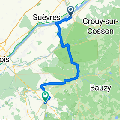
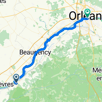
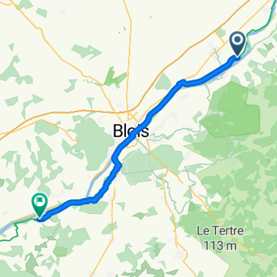
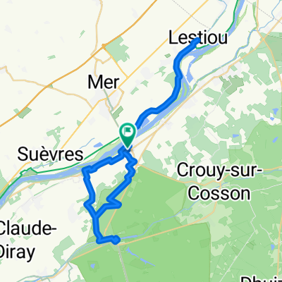
1.7. Meung sur Loire In the morning we cross the river and start cycling north along the northern bank of the Loire. At first, we ride along a good bike path built along a long flood levee until we reach Le Tetre, where we see the first nuclear power plant of the trip (even though there are 59 in France, we haven't encountered any until now). The journey continues on bike paths and country roads following the bank of the Loire to Beaugency (where there is a 22-arch bridge over the Loire) and further to Meung, where it seems there is a market. Mainly vegetables and clothes are sold along the streets in the center. At the beginning of the return trip, we try to access the riverside paths, but we have to turn back twice, as the path ends at a fence or a field. Therefore, the return trip takes place almost along the same route as the outbound one.
- -:--
- Duration
- 54.1 km
- Distance
- 67 m
- Ascent
- 69 m
- Descent
- ---
- Avg. speed
- ---
- Max. altitude

Route quality
Waytypes & surfaces along the route
Waytypes
Quiet road
18.4 km
(34 %)
Track
18.4 km
(34 %)
Surfaces
Paved
21.1 km
(39 %)
Unpaved
14.6 km
(27 %)
Asphalt
20 km
(37 %)
Gravel
9.7 km
(18 %)
Continue with Bikemap
Use, edit, or download this cycling route
You would like to ride Meung sur Loire or customize it for your own trip? Here is what you can do with this Bikemap route:
Free features
- Save this route as favorite or in collections
- Copy & plan your own version of this route
- Sync your route with Garmin or Wahoo
Premium features
Free trial for 3 days, or one-time payment. More about Bikemap Premium.
- Navigate this route on iOS & Android
- Export a GPX / KML file of this route
- Create your custom printout (try it for free)
- Download this route for offline navigation
Discover more Premium features.
Get Bikemap PremiumFrom our community
Other popular routes starting in Muides-sur-Loire
 Importierte Route
- Distance
- 33.6 km
- Ascent
- 162 m
- Descent
- 160 m
- Location
- Muides-sur-Loire, Centre-Val de Loire, France
 Capfun - Blois
- Distance
- 47 km
- Ascent
- 1,605 m
- Descent
- 1,566 m
- Location
- Muides-sur-Loire, Centre-Val de Loire, France
 Blois Noirmoutier part 1
- Distance
- 286.2 km
- Ascent
- 229 m
- Descent
- 309 m
- Location
- Muides-sur-Loire, Centre-Val de Loire, France
 BFCiC Loire 2009
- Distance
- 377.5 km
- Ascent
- 1,261 m
- Descent
- 1,313 m
- Location
- Muides-sur-Loire, Centre-Val de Loire, France
 From Muides-sur-Loire to Orléans
- Distance
- 46.3 km
- Ascent
- 108 m
- Descent
- 82 m
- Location
- Muides-sur-Loire, Centre-Val de Loire, France
 Muides-sur-Loire - Chaumont-sur-Loire
- Distance
- 45.6 km
- Ascent
- 175 m
- Descent
- 164 m
- Location
- Muides-sur-Loire, Centre-Val de Loire, France
 Meung sur Loire
- Distance
- 54.1 km
- Ascent
- 67 m
- Descent
- 69 m
- Location
- Muides-sur-Loire, Centre-Val de Loire, France
 Muides/Lestiou/Chambord/Muides
- Distance
- 42.3 km
- Ascent
- 140 m
- Descent
- 141 m
- Location
- Muides-sur-Loire, Centre-Val de Loire, France
Open it in the app