

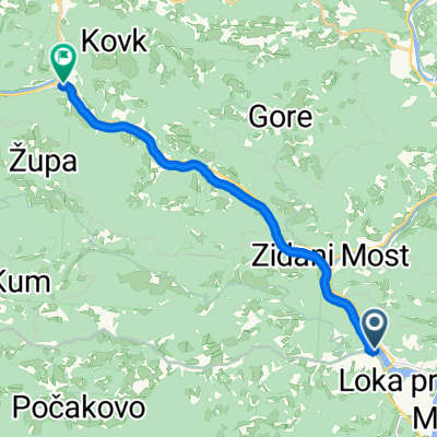
Jagnjenica-Podkum-Polšnik-Mamolj-Gradiške laze-Velika Preska-Dole-Jagnjenica
A cycling route starting in Radeče, Radeče Municipality, Slovenia.
Overview
About this route
- -:--
- Duration
- 74.3 km
- Distance
- 3,312 m
- Ascent
- 3,317 m
- Descent
- ---
- Avg. speed
- 824 m
- Max. altitude

Continue with Bikemap
Use, edit, or download this cycling route
You would like to ride Jagnjenica-Podkum-Polšnik-Mamolj-Gradiške laze-Velika Preska-Dole-Jagnjenica or customize it for your own trip? Here is what you can do with this Bikemap route:
Free features
- Save this route as favorite or in collections
- Copy & plan your own version of this route
- Sync your route with Garmin or Wahoo
Premium features
Free trial for 3 days, or one-time payment. More about Bikemap Premium.
- Navigate this route on iOS & Android
- Export a GPX / KML file of this route
- Create your custom printout (try it for free)
- Download this route for offline navigation
Discover more Premium features.
Get Bikemap PremiumFrom our community
Other popular routes starting in Radeče
 1: Na Lisco
- Distance
- 29.6 km
- Ascent
- 911 m
- Descent
- 910 m
- Location
- Radeče, Radeče Municipality, Slovenia
 Jagnjenica-Podkum-Polšnik-Mamolj-Gradiške laze-Velika Preska-Dole-Jagnjenica
- Distance
- 74.3 km
- Ascent
- 3,312 m
- Descent
- 3,317 m
- Location
- Radeče, Radeče Municipality, Slovenia
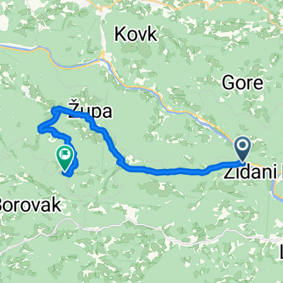
 Zidani Most-Logarska Dolina
- Distance
- 97.2 km
- Ascent
- 982 m
- Descent
- 175 m
- Location
- Radeče, Radeče Municipality, Slovenia
 breg okroglice lisca sevnica kompolje breg
- Distance
- 37 km
- Ascent
- 954 m
- Descent
- 954 m
- Location
- Radeče, Radeče Municipality, Slovenia
 Radeče+Sevniški maraton
- Distance
- 82.3 km
- Ascent
- 635 m
- Descent
- 677 m
- Location
- Radeče, Radeče Municipality, Slovenia
 Route to Mirna gora
- Distance
- 77.9 km
- Ascent
- 2,358 m
- Descent
- 1,524 m
- Location
- Radeče, Radeče Municipality, Slovenia
 Radeče to Hrastnik
- Distance
- 10.5 km
- Ascent
- 204 m
- Descent
- 127 m
- Location
- Radeče, Radeče Municipality, Slovenia
 podkraj-kum
- Distance
- 12.5 km
- Ascent
- 1,167 m
- Descent
- 257 m
- Location
- Radeče, Radeče Municipality, Slovenia
Open it in the app