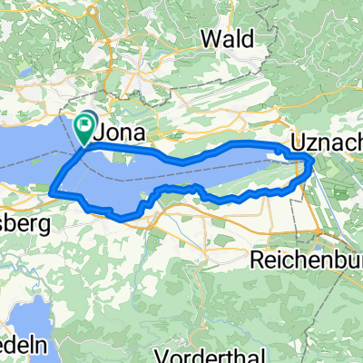
flucht vor der hitze...
A cycling route starting in Rapperswil, Canton of St. Gallen, Switzerland.
Overview
About this route
nice tour in the highlands, with lakes for cooling off in great heat... tested on June 30 at over 32°C...
- -:--
- Duration
- 117.4 km
- Distance
- 1,603 m
- Ascent
- 1,603 m
- Descent
- ---
- Avg. speed
- ---
- Max. altitude
Route quality
Waytypes & surfaces along the route
Waytypes
Road
37.6 km
(32 %)
Quiet road
23.5 km
(20 %)
Surfaces
Paved
96.2 km
(82 %)
Asphalt
95.1 km
(81 %)
Paved (undefined)
1.2 km
(1 %)
Undefined
21.1 km
(18 %)
Continue with Bikemap
Use, edit, or download this cycling route
You would like to ride flucht vor der hitze... or customize it for your own trip? Here is what you can do with this Bikemap route:
Free features
- Save this route as favorite or in collections
- Copy & plan your own version of this route
- Split it into stages to create a multi-day tour
- Sync your route with Garmin or Wahoo
Premium features
Free trial for 3 days, or one-time payment. More about Bikemap Premium.
- Navigate this route on iOS & Android
- Export a GPX / KML file of this route
- Create your custom printout (try it for free)
- Download this route for offline navigation
Discover more Premium features.
Get Bikemap PremiumFrom our community
Other popular routes starting in Rapperswil
- Walensee-Rheintal-Appenzell
- Distance
- 174.7 km
- Ascent
- 1,275 m
- Descent
- 1,270 m
- Location
- Rapperswil, Canton of St. Gallen, Switzerland
- JN 4.2 Vierwaldstädter See
- Distance
- 65.3 km
- Ascent
- 789 m
- Descent
- 776 m
- Location
- Rapperswil, Canton of St. Gallen, Switzerland
- Rund um die Rigi
- Distance
- 119.8 km
- Ascent
- 1,070 m
- Descent
- 1,067 m
- Location
- Rapperswil, Canton of St. Gallen, Switzerland
- Schönbodenweg 54, Rapperswil-Jona nach Schönbodenweg 54, Rapperswil-Jona
- Distance
- 31.3 km
- Ascent
- 321 m
- Descent
- 320 m
- Location
- Rapperswil, Canton of St. Gallen, Switzerland
- Schönbodenstrasse 56, Rapperswil-Jona nach Schönbodenstrasse 56, Rapperswil-Jona
- Distance
- 38.5 km
- Ascent
- 293 m
- Descent
- 293 m
- Location
- Rapperswil, Canton of St. Gallen, Switzerland
- Day 6: Turbental
- Distance
- 83 km
- Ascent
- 0 m
- Descent
- 0 m
- Location
- Rapperswil, Canton of St. Gallen, Switzerland
- Rapperswil-Jona nach Rhein (Zweidlen). Neu: "Geheimer" Gleisweg Eglisau - Zweidlen (eine Verlängerung in den Schatten). Achtung: Beim Hochwasser: überflütet
- Distance
- 67.2 km
- Ascent
- 749 m
- Descent
- 803 m
- Location
- Rapperswil, Canton of St. Gallen, Switzerland
- Kempraten-Atzmännig-Hiltisberg-Kempraten
- Distance
- 44.6 km
- Ascent
- 649 m
- Descent
- 643 m
- Location
- Rapperswil, Canton of St. Gallen, Switzerland
Open it in the app