

Tour 1
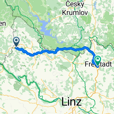
A cycling route starting in Nebelberg, Upper Austria, Austria.
Overview
About this route
- 2 h 29 min
- Duration
- 48.2 km
- Distance
- 949 m
- Ascent
- 925 m
- Descent
- 19.4 km/h
- Avg. speed
- 878 m
- Max. altitude
Route quality
Waytypes & surfaces along the route
Waytypes
Quiet road
25.1 km
(52 %)
Track
21.7 km
(45 %)
Surfaces
Paved
3.9 km
(8 %)
Unpaved
16.4 km
(34 %)
Gravel
7.2 km
(15 %)
Ground
6.7 km
(14 %)
Continue with Bikemap
Use, edit, or download this cycling route
You would like to ride Tour 1 or customize it for your own trip? Here is what you can do with this Bikemap route:
Free features
- Save this route as favorite or in collections
- Copy & plan your own version of this route
- Sync your route with Garmin or Wahoo
Premium features
Free trial for 3 days, or one-time payment. More about Bikemap Premium.
- Navigate this route on iOS & Android
- Export a GPX / KML file of this route
- Create your custom printout (try it for free)
- Download this route for offline navigation
Discover more Premium features.
Get Bikemap PremiumFrom our community
Other popular routes starting in Nebelberg
 Pfk-Runde
- Distance
- 46 km
- Ascent
- 1,030 m
- Descent
- 1,028 m
- Location
- Nebelberg, Upper Austria, Austria
 Haselbachrunde erweitert
- Distance
- 34.9 km
- Ascent
- 877 m
- Descent
- 871 m
- Location
- Nebelberg, Upper Austria, Austria
 Vnb - Rinnmühle - Unterthiergrub - Kriegwald - hoam
- Distance
- 29.7 km
- Ascent
- 814 m
- Descent
- 812 m
- Location
- Nebelberg, Upper Austria, Austria
 Nusssteig 15 bis Nusssteig 15
- Distance
- 39.5 km
- Ascent
- 924 m
- Descent
- 924 m
- Location
- Nebelberg, Upper Austria, Austria
 Kollerschlag nach Freistadt
- Distance
- 72 km
- Ascent
- 1,817 m
- Descent
- 1,995 m
- Location
- Nebelberg, Upper Austria, Austria
 Fitnessrunde; Lengau-Haselbach-Blutwurzhütte-Kohlstatt
- Distance
- 44.1 km
- Ascent
- 587 m
- Descent
- 575 m
- Location
- Nebelberg, Upper Austria, Austria
 Zwieselberg
- Distance
- 49.1 km
- Ascent
- 1,085 m
- Descent
- 1,084 m
- Location
- Nebelberg, Upper Austria, Austria
 Unbenannte Route
- Distance
- 42.6 km
- Ascent
- 1,064 m
- Descent
- 1,065 m
- Location
- Nebelberg, Upper Austria, Austria
Open it in the app