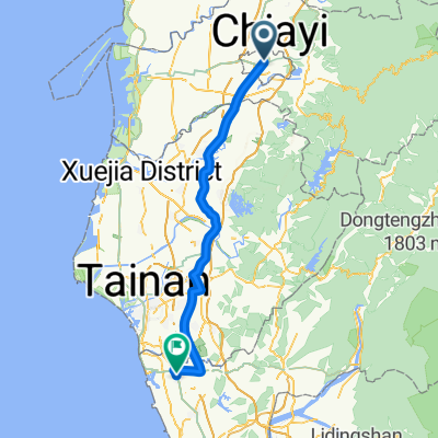
Day4:嘉義→台南
A cycling route starting in Pizitou, Taiwan, Taiwan.
Overview
About this route
<span style="margin: 0px; padding: 0px; font-family: 'Times New Roman'; color: #000000; font-size: small;">★距離:68KM</span>
<span style="margin: 0px; padding: 0px; font-family: 'Times New Roman'; color: #000000; font-size: small;">★難度:★</span>
<span style="margin: 0px; padding: 0px; font-family: 'Times New Roman'; color: #000000; font-size: small;">★路線:</span>
<span style="margin: 0px; padding: 0px; font-family: 'Times New Roman'; color: #000000; font-size: small;">★ 景點:成功大學、台南古蹟、小吃<br /><br />★狀況好可繞到七股</span>
- -:--
- Duration
- 67.3 km
- Distance
- 82 m
- Ascent
- 93 m
- Descent
- ---
- Avg. speed
- ---
- Avg. speed
Continue with Bikemap
Use, edit, or download this cycling route
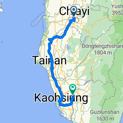
You would like to ride Day4:嘉義→台南 or customize it for your own trip? Here is what you can do with this Bikemap route:
Free features
- Save this route as favorite or in collections
- Copy & plan your own version of this route
- Sync your route with Garmin or Wahoo
Premium features
Free trial for 3 days, or one-time payment. More about Bikemap Premium.
- Navigate this route on iOS & Android
- Export a GPX / KML file of this route
- Create your custom printout (try it for free)
- Download this route for offline navigation
Discover more Premium features.
Get Bikemap PremiumFrom our community
Other popular routes starting in Pizitou
- 大林車站-梅山36彎-太平老街
- Distance
- 24.9 km
- Ascent
- 943 m
- Descent
- 17 m
- Location
- Pizitou, Taiwan, Taiwan
- Day 04
- Distance
- 110.8 km
- Ascent
- 21 m
- Descent
- 48 m
- Location
- Pizitou, Taiwan, Taiwan
- 嘉義大林來吉嘉義市
- Distance
- 129 km
- Ascent
- 2,354 m
- Descent
- 2,355 m
- Location
- Pizitou, Taiwan, Taiwan
- 環島D2
- Distance
- 128.8 km
- Ascent
- 102 m
- Descent
- 101 m
- Location
- Pizitou, Taiwan, Taiwan
- 雙港騎福---民雄-新港-板陶窯-北港
- Distance
- 16.6 km
- Ascent
- 13 m
- Descent
- 31 m
- Location
- Pizitou, Taiwan, Taiwan
- 嘉義中正大學至東石漁港(166)
- Distance
- 84.8 km
- Ascent
- 105 m
- Descent
- 105 m
- Location
- Pizitou, Taiwan, Taiwan
- 36彎直攻塔塔加大環線
- Distance
- 254.5 km
- Ascent
- 3,191 m
- Descent
- 3,191 m
- Location
- Pizitou, Taiwan, Taiwan
- 沿阿里山鐵路騎上山RR
- Distance
- 110.8 km
- Ascent
- 5,652 m
- Descent
- 3,479 m
- Location
- Pizitou, Taiwan, Taiwan
Open it in the app