
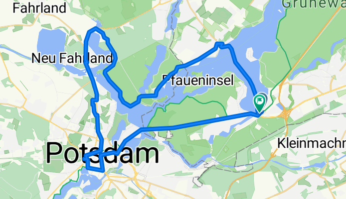
50 km Wannsee Runde
A cycling route starting in Wannsee, State of Berlin, Germany.
Overview
About this route
50 km Teielweise auf Verkehrsberuhigter Srecke.
Zwei steilere Anstiege:<br />1. Anstieg zum Grunewaldturm<br />2. Anstieg Schäferberg (Fernsehturm)
Ziel: Biergarten Loretta am S-Bahnhof Wannsee
- 2 h 36 min
- Duration
- 36.4 km
- Distance
- 232 m
- Ascent
- 234 m
- Descent
- 14 km/h
- Avg. speed
- 67 m
- Max. altitude
Route quality
Waytypes & surfaces along the route
Waytypes
Quiet road
12 km
(33 %)
Cycleway
6.5 km
(18 %)
Surfaces
Paved
21.4 km
(59 %)
Unpaved
4.7 km
(13 %)
Asphalt
21.4 km
(59 %)
Loose gravel
4 km
(11 %)
Continue with Bikemap
Use, edit, or download this cycling route
You would like to ride 50 km Wannsee Runde or customize it for your own trip? Here is what you can do with this Bikemap route:
Free features
- Save this route as favorite or in collections
- Copy & plan your own version of this route
- Sync your route with Garmin or Wahoo
Premium features
Free trial for 3 days, or one-time payment. More about Bikemap Premium.
- Navigate this route on iOS & Android
- Export a GPX / KML file of this route
- Create your custom printout (try it for free)
- Download this route for offline navigation
Discover more Premium features.
Get Bikemap PremiumFrom our community
Other popular routes starting in Wannsee
 50 km Giro di Wannsee
- Distance
- 47 km
- Ascent
- 270 m
- Descent
- 270 m
- Location
- Wannsee, State of Berlin, Germany
 Wannsee-Runde
- Distance
- 17.3 km
- Ascent
- 126 m
- Descent
- 128 m
- Location
- Wannsee, State of Berlin, Germany
 Steglitz-Zehlendorf, Berlin nach Steglitz-Zehlendorf, Berlin
- Distance
- 2.7 km
- Ascent
- 86 m
- Descent
- 97 m
- Location
- Wannsee, State of Berlin, Germany
 Wannseerunde
- Distance
- 20.6 km
- Ascent
- 119 m
- Descent
- 124 m
- Location
- Wannsee, State of Berlin, Germany
 gemütliche
- Distance
- 11.3 km
- Ascent
- 163 m
- Descent
- 163 m
- Location
- Wannsee, State of Berlin, Germany
 Berliner Mauerweg Teil 2: Vom Wannsee bis zum Hauptbahnhof
- Distance
- 80.2 km
- Ascent
- 130 m
- Descent
- 144 m
- Location
- Wannsee, State of Berlin, Germany
 Wannsee - Jungfernsee - Griebnitzsee - Gasthausbrauerei Meierei
- Distance
- 25.8 km
- Ascent
- 60 m
- Descent
- 55 m
- Location
- Wannsee, State of Berlin, Germany
 Berlin Wannsee- Brandenburg
- Distance
- 49.3 km
- Ascent
- 119 m
- Descent
- 131 m
- Location
- Wannsee, State of Berlin, Germany
Open it in the app