
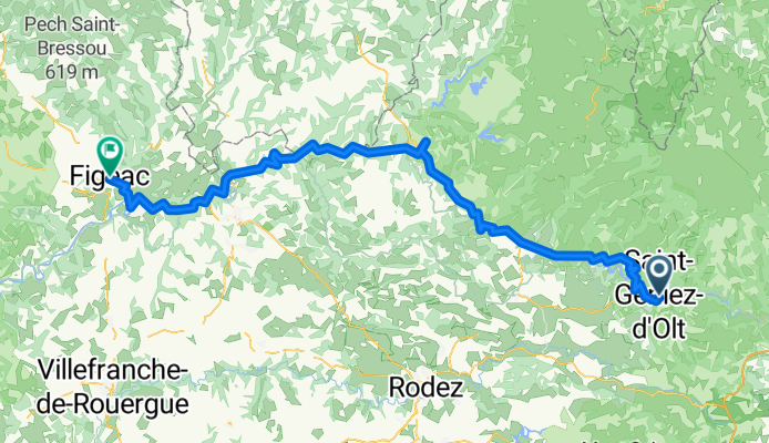
saint genies d'olt-figeac
A cycling route starting in Laissac, Occitanie, France.
Overview
About this route
- -:--
- Duration
- 119.8 km
- Distance
- 596 m
- Ascent
- 816 m
- Descent
- ---
- Avg. speed
- ---
- Max. altitude
Route quality
Waytypes & surfaces along the route
Waytypes
Busy road
100.7 km
(84 %)
Road
8.6 km
(7 %)
Surfaces
Paved
90.8 km
(76 %)
Asphalt
90.8 km
(76 %)
Undefined
29 km
(24 %)
Route highlights
Points of interest along the route
Point of interest after 8.3 km
Point of interest after 23.1 km
Point of interest after 28 km
Point of interest after 37.5 km
Point of interest after 37.5 km
Point of interest after 37.6 km
Continue with Bikemap
Use, edit, or download this cycling route
You would like to ride saint genies d'olt-figeac or customize it for your own trip? Here is what you can do with this Bikemap route:
Free features
- Save this route as favorite or in collections
- Copy & plan your own version of this route
- Split it into stages to create a multi-day tour
- Sync your route with Garmin or Wahoo
Premium features
Free trial for 3 days, or one-time payment. More about Bikemap Premium.
- Navigate this route on iOS & Android
- Export a GPX / KML file of this route
- Create your custom printout (try it for free)
- Download this route for offline navigation
Discover more Premium features.
Get Bikemap PremiumFrom our community
Other popular routes starting in Laissac
 durch die Aubrac nach Neuveglise und Saint Fleur
- Distance
- 86.9 km
- Ascent
- 1,877 m
- Descent
- 1,521 m
- Location
- Laissac, Occitanie, France
 St-Geniez d'olt to Marvejols
- Distance
- 44.2 km
- Ascent
- 592 m
- Descent
- 366 m
- Location
- Laissac, Occitanie, France
 2 Lotissement le Levant, Saint Geniez d'Olt et d'Aubrac à 6 Rue Festive, Ségur-les-Villas
- Distance
- 122.8 km
- Ascent
- 2,836 m
- Descent
- 2,262 m
- Location
- Laissac, Occitanie, France
 13 Fournel
- Distance
- 57.2 km
- Ascent
- 1,344 m
- Descent
- 822 m
- Location
- Laissac, Occitanie, France
 Tour de France 2017 - Stage 15
- Distance
- 192.5 km
- Ascent
- 2,036 m
- Descent
- 1,991 m
- Location
- Laissac, Occitanie, France
 Saint-Geniez-d'Olt, Saint Geniez d'Olt et d'Aubrac à 5 Rue des Docteurs Josette et René Roche, Riom-ès-Montagnes
- Distance
- 245 km
- Ascent
- 5,876 m
- Descent
- 5,522 m
- Location
- Laissac, Occitanie, France
 Rando route Lozère - étape 8
- Distance
- 29.6 km
- Ascent
- 471 m
- Descent
- 342 m
- Location
- Laissac, Occitanie, France
 saint genies d'olt-figeac
- Distance
- 119.8 km
- Ascent
- 596 m
- Descent
- 816 m
- Location
- Laissac, Occitanie, France
Open it in the app