

Krenglbach - St. Agatha - Haibach - Scharten
A cycling route starting in Bad Schallerbach, Upper Austria, Austria.
Overview
About this route
Krenglbach-Gallspach-Grieskirchen-
Waizenkirchen-St.Agatha-Haibach-Harkichen-
Eferding-Scharten-Krenglbach
- -:--
- Duration
- 83.2 km
- Distance
- 892 m
- Ascent
- 897 m
- Descent
- ---
- Avg. speed
- 604 m
- Max. altitude
Route quality
Waytypes & surfaces along the route
Waytypes
Busy road
63.5 km
(76 %)
Road
8.5 km
(10 %)
Surfaces
Paved
29.7 km
(36 %)
Asphalt
28.7 km
(34 %)
Paved (undefined)
1.1 km
(1 %)
Undefined
53.4 km
(64 %)
Continue with Bikemap
Use, edit, or download this cycling route
You would like to ride Krenglbach - St. Agatha - Haibach - Scharten or customize it for your own trip? Here is what you can do with this Bikemap route:
Free features
- Save this route as favorite or in collections
- Copy & plan your own version of this route
- Split it into stages to create a multi-day tour
- Sync your route with Garmin or Wahoo
Premium features
Free trial for 3 days, or one-time payment. More about Bikemap Premium.
- Navigate this route on iOS & Android
- Export a GPX / KML file of this route
- Create your custom printout (try it for free)
- Download this route for offline navigation
Discover more Premium features.
Get Bikemap PremiumFrom our community
Other popular routes starting in Bad Schallerbach
 140km Pichl - Wesenufer - St. Martin - Scharten - Pichl
- Distance
- 140.9 km
- Ascent
- 1,160 m
- Descent
- 1,160 m
- Location
- Bad Schallerbach, Upper Austria, Austria
 2014 - Pichl / Inzing (400km / 4400Hm)
- Distance
- 392.8 km
- Ascent
- 3,329 m
- Descent
- 3,096 m
- Location
- Bad Schallerbach, Upper Austria, Austria
 Krenglbach - Gunskirchen - Traun - Pasching (PlusCity) - Krenglbach
- Distance
- 69.2 km
- Ascent
- 214 m
- Descent
- 211 m
- Location
- Bad Schallerbach, Upper Austria, Austria
 Krenglbach Rennradrunde
- Distance
- 48.2 km
- Ascent
- 399 m
- Descent
- 390 m
- Location
- Bad Schallerbach, Upper Austria, Austria
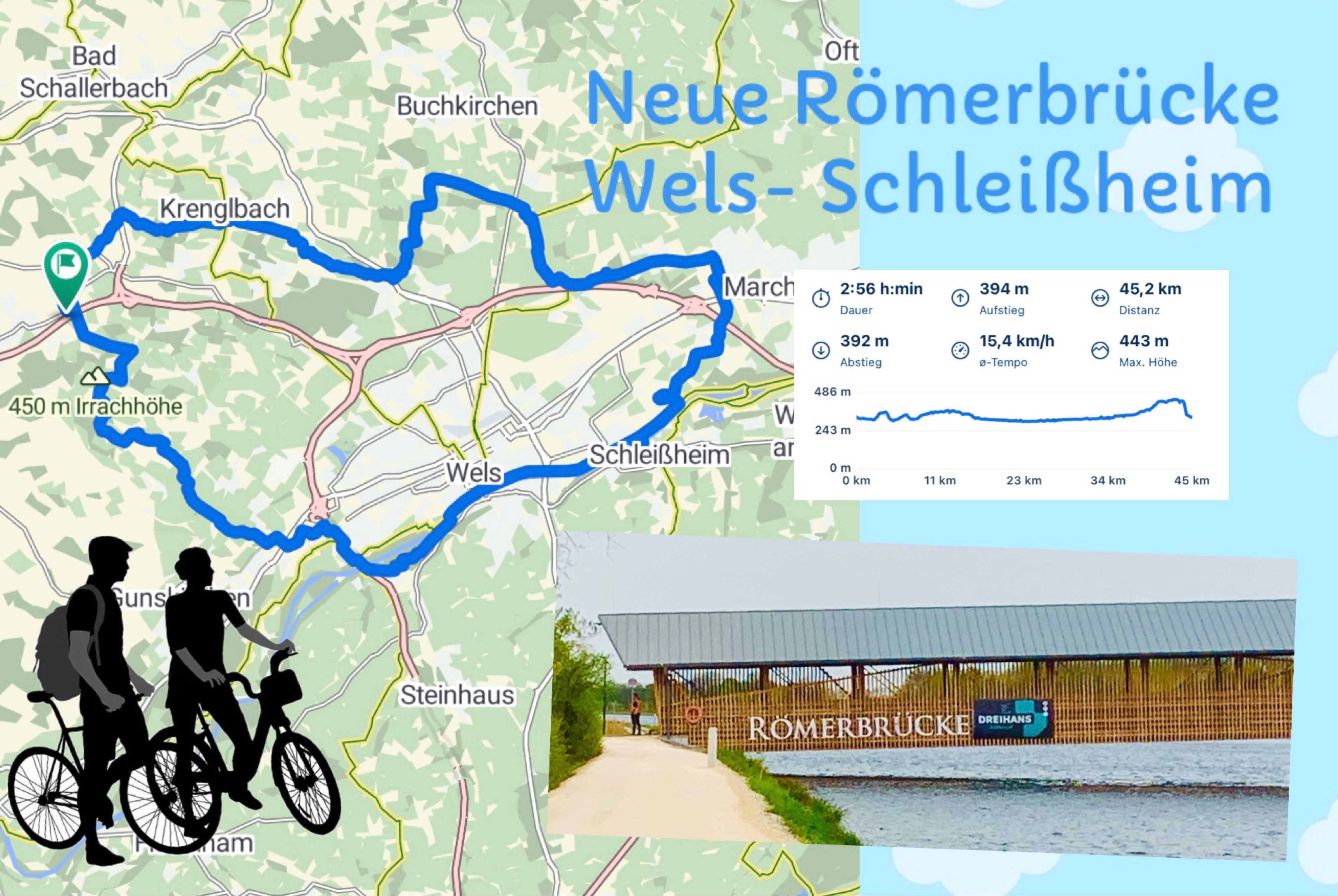 OBK 250417 RÖMERBRÜCKE
- Distance
- 45.2 km
- Ascent
- 394 m
- Descent
- 392 m
- Location
- Bad Schallerbach, Upper Austria, Austria
 Vorschlag 1. Mai
- Distance
- 17.4 km
- Ascent
- 221 m
- Descent
- 222 m
- Location
- Bad Schallerbach, Upper Austria, Austria
 Krenglbach - St. Agatha - Haibach - Scharten
- Distance
- 83.2 km
- Ascent
- 892 m
- Descent
- 897 m
- Location
- Bad Schallerbach, Upper Austria, Austria
 OBK KALKI/Albenedt
- Distance
- 31.2 km
- Ascent
- 376 m
- Descent
- 247 m
- Location
- Bad Schallerbach, Upper Austria, Austria
Open it in the app