
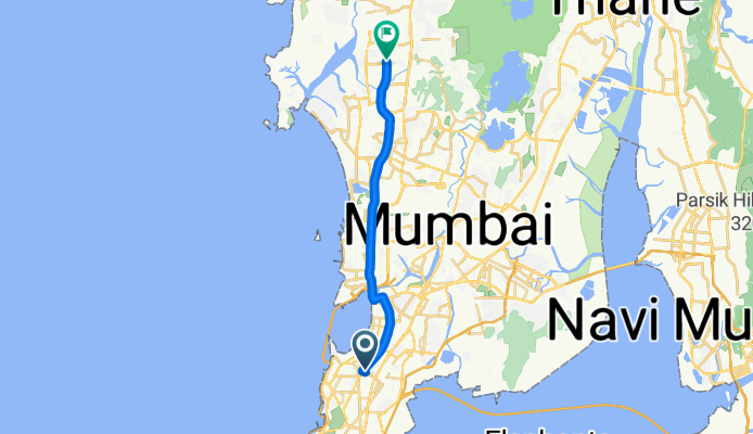
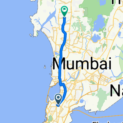
Route in Mumbai
A cycling route starting in Mumbai, Maharashtra, India.
Overview
About this route
- 1 h 11 min
- Duration
- 19.5 km
- Distance
- 54 m
- Ascent
- 45 m
- Descent
- 16.4 km/h
- Avg. speed
- 24 m
- Max. altitude
Continue with Bikemap
Use, edit, or download this cycling route
You would like to ride Route in Mumbai or customize it for your own trip? Here is what you can do with this Bikemap route:
Free features
- Save this route as favorite or in collections
- Copy & plan your own version of this route
- Sync your route with Garmin or Wahoo
Premium features
Free trial for 3 days, or one-time payment. More about Bikemap Premium.
- Navigate this route on iOS & Android
- Export a GPX / KML file of this route
- Create your custom printout (try it for free)
- Download this route for offline navigation
Discover more Premium features.
Get Bikemap PremiumFrom our community
Other popular routes starting in Mumbai
 Route in Mumbai
- Distance
- 19.5 km
- Ascent
- 54 m
- Descent
- 45 m
- Location
- Mumbai, Maharashtra, India
 another way home
- Distance
- 5.2 km
- Ascent
- 13 m
- Descent
- 12 m
- Location
- Mumbai, Maharashtra, India
 Route from Bhakti Dham Mandir Road, Mumbai
- Distance
- 19.4 km
- Ascent
- 3 m
- Descent
- 7 m
- Location
- Mumbai, Maharashtra, India
 ghatkopar to gholvad
- Distance
- 194.6 km
- Ascent
- 1,173 m
- Descent
- 1,184 m
- Location
- Mumbai, Maharashtra, India
 From Mumbai to Nagpur
- Distance
- 1,174.3 km
- Ascent
- 7,199 m
- Descent
- 6,890 m
- Location
- Mumbai, Maharashtra, India
 bandra garden to bandstand
- Distance
- 3.9 km
- Ascent
- 14 m
- Descent
- 18 m
- Location
- Mumbai, Maharashtra, India
 Doctor Annie Besant Road to Mumbai
- Distance
- 1 km
- Ascent
- 13 m
- Descent
- 18 m
- Location
- Mumbai, Maharashtra, India
 H4, Mumbai to Natyakarmi Sunil Premanand Kambli Marg A-8, Mumbai
- Distance
- 14.8 km
- Ascent
- 121 m
- Descent
- 125 m
- Location
- Mumbai, Maharashtra, India
Open it in the app