
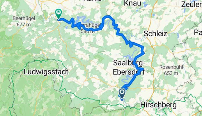
Day 2 Harra - Kaulsdorf
A cycling route starting in Harra, Thuringia, Germany.
Overview
About this route
- -:--
- Duration
- 71.7 km
- Distance
- 1,270 m
- Ascent
- 1,494 m
- Descent
- ---
- Avg. speed
- 535 m
- Max. altitude
Continue with Bikemap
Use, edit, or download this cycling route
You would like to ride Day 2 Harra - Kaulsdorf or customize it for your own trip? Here is what you can do with this Bikemap route:
Free features
- Save this route as favorite or in collections
- Copy & plan your own version of this route
- Sync your route with Garmin or Wahoo
Premium features
Free trial for 3 days, or one-time payment. More about Bikemap Premium.
- Navigate this route on iOS & Android
- Export a GPX / KML file of this route
- Create your custom printout (try it for free)
- Download this route for offline navigation
Discover more Premium features.
Get Bikemap PremiumFrom our community
Other popular routes starting in Harra
 Am Stausee 4, Rosenthal am Rennsteig nach Am Stausee 4, Rosenthal am Rennsteig
- Distance
- 37 km
- Ascent
- 207 m
- Descent
- 346 m
- Location
- Harra, Thuringia, Germany
 Dienstag - Harra- Saalfeld
- Distance
- 78.2 km
- Ascent
- 1,555 m
- Descent
- 1,772 m
- Location
- Harra, Thuringia, Germany
 Am Stausee 4, Rosenthal am Rennsteig nach L1104, Schmorda
- Distance
- 48.6 km
- Ascent
- 794 m
- Descent
- 714 m
- Location
- Harra, Thuringia, Germany
 Day 2 Harra - Kaulsdorf
- Distance
- 71.7 km
- Ascent
- 1,270 m
- Descent
- 1,494 m
- Location
- Harra, Thuringia, Germany
 2. Etappe von Harra nach Eichicht 70 Km
- Distance
- 70.6 km
- Ascent
- 1,470 m
- Descent
- 1,709 m
- Location
- Harra, Thuringia, Germany
 Schulstraße 8, Rosenthal am Rennsteig nach Schulstraße 10, Rosenthal am Rennsteig
- Distance
- 6.1 km
- Ascent
- 88 m
- Descent
- 98 m
- Location
- Harra, Thuringia, Germany
 harra-eichicht
- Distance
- 69.8 km
- Ascent
- 1,334 m
- Descent
- 1,557 m
- Location
- Harra, Thuringia, Germany
 Saaldorf nach Markt
- Distance
- 12.1 km
- Ascent
- 302 m
- Descent
- 311 m
- Location
- Harra, Thuringia, Germany
Open it in the app