

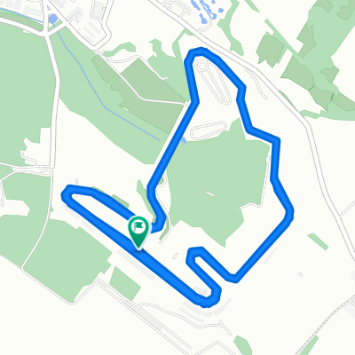
Budapest-Romhány kör 1. nap
A cycling route starting in Mogyoród, Pest County, Hungary.
Overview
About this route
Departure: Őrs vezér tere
By HÉV to Mogyoród
Accommodation: Romhány Fáradt Vándor
- -:--
- Duration
- 55.1 km
- Distance
- 275 m
- Ascent
- 388 m
- Descent
- ---
- Avg. speed
- ---
- Max. altitude
Route quality
Waytypes & surfaces along the route
Waytypes
Road
5.5 km
(10 %)
Quiet road
5.5 km
(10 %)
Surfaces
Paved
44.6 km
(81 %)
Asphalt
44.6 km
(81 %)
Undefined
10.5 km
(19 %)
Route highlights
Points of interest along the route
Point of interest after 0 km
Continue with Bikemap
Use, edit, or download this cycling route
You would like to ride Budapest-Romhány kör 1. nap or customize it for your own trip? Here is what you can do with this Bikemap route:
Free features
- Save this route as favorite or in collections
- Copy & plan your own version of this route
- Sync your route with Garmin or Wahoo
Premium features
Free trial for 3 days, or one-time payment. More about Bikemap Premium.
- Navigate this route on iOS & Android
- Export a GPX / KML file of this route
- Create your custom printout (try it for free)
- Download this route for offline navigation
Discover more Premium features.
Get Bikemap PremiumFrom our community
Other popular routes starting in Mogyoród
 Miénk a pálya! - Hungaroring 2015
- Distance
- 4.4 km
- Ascent
- 59 m
- Descent
- 59 m
- Location
- Mogyoród, Pest County, Hungary
 Budapest-Romhány kör 1. nap
- Distance
- 55.1 km
- Ascent
- 275 m
- Descent
- 388 m
- Location
- Mogyoród, Pest County, Hungary
 Mogyoród-Romhány-Vác-Budapest
- Distance
- 139.7 km
- Ascent
- 467 m
- Descent
- 623 m
- Location
- Mogyoród, Pest County, Hungary
 Hungaroring - kör
- Distance
- 3.3 km
- Ascent
- 67 m
- Descent
- 64 m
- Location
- Mogyoród, Pest County, Hungary
 Hungaroring- edzőkör
- Distance
- 13.6 km
- Ascent
- 218 m
- Descent
- 218 m
- Location
- Mogyoród, Pest County, Hungary
 F1 pálya
- Distance
- 4.4 km
- Ascent
- 65 m
- Descent
- 63 m
- Location
- Mogyoród, Pest County, Hungary
 Nyugodt útvonal
- Distance
- 11.7 km
- Ascent
- 132 m
- Descent
- 134 m
- Location
- Mogyoród, Pest County, Hungary
Open it in the app