
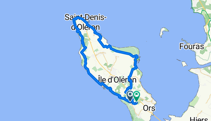
Chemin des Rouesses d'Avail nach Route de la Gaconnière
A cycling route starting in Dolus-d'Oléron, Nouvelle-Aquitaine, France.
Overview
About this route
- 4 h 5 min
- Duration
- 62.9 km
- Distance
- 80 m
- Ascent
- 82 m
- Descent
- 15.4 km/h
- Avg. speed
- 21 m
- Max. altitude

Route quality
Waytypes & surfaces along the route
Waytypes
Cycleway
27.1 km
(43 %)
Quiet road
15.7 km
(25 %)
Surfaces
Paved
27.1 km
(43 %)
Unpaved
19.5 km
(31 %)
Asphalt
25.8 km
(41 %)
Gravel
18.9 km
(30 %)
Continue with Bikemap
Use, edit, or download this cycling route
You would like to ride Chemin des Rouesses d'Avail nach Route de la Gaconnière or customize it for your own trip? Here is what you can do with this Bikemap route:
Free features
- Save this route as favorite or in collections
- Copy & plan your own version of this route
- Sync your route with Garmin or Wahoo
Premium features
Free trial for 3 days, or one-time payment. More about Bikemap Premium.
- Navigate this route on iOS & Android
- Export a GPX / KML file of this route
- Create your custom printout (try it for free)
- Download this route for offline navigation
Discover more Premium features.
Get Bikemap PremiumFrom our community
Other popular routes starting in Dolus-d'Oléron
 Boucle entre Dolus d'Oléron et le phare de Chassiron
- Distance
- 55.6 km
- Ascent
- 25 m
- Descent
- 24 m
- Location
- Dolus-d'Oléron, Nouvelle-Aquitaine, France
 Long bike tour through Dolus-d'Oléron
- Distance
- 47.4 km
- Ascent
- 25 m
- Descent
- 24 m
- Location
- Dolus-d'Oléron, Nouvelle-Aquitaine, France
 tour d'oléron
- Distance
- 70.8 km
- Ascent
- 38 m
- Descent
- 38 m
- Location
- Dolus-d'Oléron, Nouvelle-Aquitaine, France
 Saint-Pierre l'aiguille Boyard Sauzelle Saint-Pierre
- Distance
- 19.3 km
- Ascent
- 50 m
- Descent
- 42 m
- Location
- Dolus-d'Oléron, Nouvelle-Aquitaine, France
 De 3bis Impasse de la Seigneurie, Saint-Pierre-d'Oléron à 4 Impasse de la Seigneurie, Saint-Pierre-d'Oléron
- Distance
- 23.7 km
- Ascent
- 15 m
- Descent
- 15 m
- Location
- Dolus-d'Oléron, Nouvelle-Aquitaine, France
 Oléron
- Distance
- 11.5 km
- Ascent
- 29 m
- Descent
- 81 m
- Location
- Dolus-d'Oléron, Nouvelle-Aquitaine, France
 cool raoul
- Distance
- 4.2 km
- Ascent
- 129 m
- Descent
- 132 m
- Location
- Dolus-d'Oléron, Nouvelle-Aquitaine, France
 5 La Cotinière-La Cotinière
- Distance
- 50.8 km
- Ascent
- 45 m
- Descent
- 46 m
- Location
- Dolus-d'Oléron, Nouvelle-Aquitaine, France
Open it in the app