

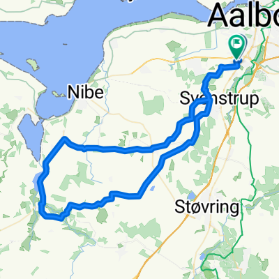
Climb Sofiendalsvej/Bejsebakkevej
A cycling route starting in Frejlev, North Denmark, Denmark.
Overview
About this route
This is a long climb, around 2 km. from start to the top. It has 52 meters of elevation (start 7 meters above sea level, top 59 meters above sea level).
- -:--
- Duration
- 2.2 km
- Distance
- 52 m
- Ascent
- 0 m
- Descent
- ---
- Avg. speed
- ---
- Max. altitude
Route quality
Waytypes & surfaces along the route
Waytypes
Road
2.2 km
(100 %)
Surfaces
Paved
2.2 km
(100 %)
Asphalt
2.2 km
(100 %)
Continue with Bikemap
Use, edit, or download this cycling route
You would like to ride Climb Sofiendalsvej/Bejsebakkevej or customize it for your own trip? Here is what you can do with this Bikemap route:
Free features
- Save this route as favorite or in collections
- Copy & plan your own version of this route
- Sync your route with Garmin or Wahoo
Premium features
Free trial for 3 days, or one-time payment. More about Bikemap Premium.
- Navigate this route on iOS & Android
- Export a GPX / KML file of this route
- Create your custom printout (try it for free)
- Download this route for offline navigation
Discover more Premium features.
Get Bikemap PremiumFrom our community
Other popular routes starting in Frejlev
 cwoe1
cwoe1- Distance
- 90.8 km
- Ascent
- 71 m
- Descent
- 66 m
- Location
- Frejlev, North Denmark, Denmark
 erewr
erewr- Distance
- 68 km
- Ascent
- 215 m
- Descent
- 213 m
- Location
- Frejlev, North Denmark, Denmark
 Climb Sofiendalsvej/Bejsebakkevej
- Distance
- 2.2 km
- Ascent
- 52 m
- Descent
- 0 m
- Location
- Frejlev, North Denmark, Denmark
 Limfjordsgade 101, Aabybro to Vadum Kirkevej 30, Vadum
- Distance
- 14.2 km
- Ascent
- 6 m
- Descent
- 6 m
- Location
- Frejlev, North Denmark, Denmark
 Frejlev - Drastrup Svenstrup - Frejlev
- Distance
- 12.9 km
- Ascent
- 63 m
- Descent
- 62 m
- Location
- Frejlev, North Denmark, Denmark
 Traing_06-05-2017
- Distance
- 31 km
- Ascent
- 152 m
- Descent
- 163 m
- Location
- Frejlev, North Denmark, Denmark
 gjøl-bonderrup
- Distance
- 46.5 km
- Ascent
- 137 m
- Descent
- 140 m
- Location
- Frejlev, North Denmark, Denmark
 Training_06-05-2017_2
- Distance
- 62.3 km
- Ascent
- 279 m
- Descent
- 289 m
- Location
- Frejlev, North Denmark, Denmark
Open it in the app