
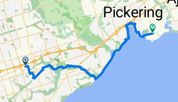
Port Union Waterfront Trail
A cycling route starting in Scarborough, Ontario, Canada.
Overview
About this route
Easy bike trail starting from Morningside Park ending at Rouge Park and back.
- 1 h 45 min
- Duration
- 26.4 km
- Distance
- 217 m
- Ascent
- 284 m
- Descent
- 15.2 km/h
- Avg. speed
- 167 m
- Max. altitude
Route quality
Waytypes & surfaces along the route
Waytypes
Cycleway
16.7 km
(63 %)
Quiet road
6.1 km
(23 %)
Surfaces
Paved
23.3 km
(88 %)
Unpaved
1.1 km
(4 %)
Asphalt
22.5 km
(85 %)
Gravel
0.5 km
(2 %)
Continue with Bikemap
Use, edit, or download this cycling route
You would like to ride Port Union Waterfront Trail or customize it for your own trip? Here is what you can do with this Bikemap route:
Free features
- Save this route as favorite or in collections
- Copy & plan your own version of this route
- Sync your route with Garmin or Wahoo
Premium features
Free trial for 3 days, or one-time payment. More about Bikemap Premium.
- Navigate this route on iOS & Android
- Export a GPX / KML file of this route
- Create your custom printout (try it for free)
- Download this route for offline navigation
Discover more Premium features.
Get Bikemap PremiumFrom our community
Other popular routes starting in Scarborough
 Biking Line 2
- Distance
- 28.3 km
- Ascent
- 195 m
- Descent
- 235 m
- Location
- Scarborough, Ontario, Canada
 TO35Cycles + Ward 36 Cyclists 2015-December Loop
- Distance
- 27.5 km
- Ascent
- 223 m
- Descent
- 223 m
- Location
- Scarborough, Ontario, Canada
 Crockford Blvd, Toronto to Fitzgibbon Ave, Toronto
- Distance
- 7.1 km
- Ascent
- 16 m
- Descent
- 19 m
- Location
- Scarborough, Ontario, Canada
 Ride around Scarborough Ontario
- Distance
- 25.9 km
- Ascent
- 180 m
- Descent
- 182 m
- Location
- Scarborough, Ontario, Canada
 Scarborough-Orangeville Loop
- Distance
- 167.3 km
- Ascent
- 523 m
- Descent
- 523 m
- Location
- Scarborough, Ontario, Canada
 Scarborough to Oshawa via Toronto
- Distance
- 83.1 km
- Ascent
- 420 m
- Descent
- 481 m
- Location
- Scarborough, Ontario, Canada
 Scarb Town --> Frenchmans via direct route
- Distance
- 20.4 km
- Ascent
- 76 m
- Descent
- 147 m
- Location
- Scarborough, Ontario, Canada
 Gatineau Hydro Corridor Tr, Toronto to Fitzgibbon Ave, Toronto
- Distance
- 9.1 km
- Ascent
- 39 m
- Descent
- 48 m
- Location
- Scarborough, Ontario, Canada
Open it in the app