
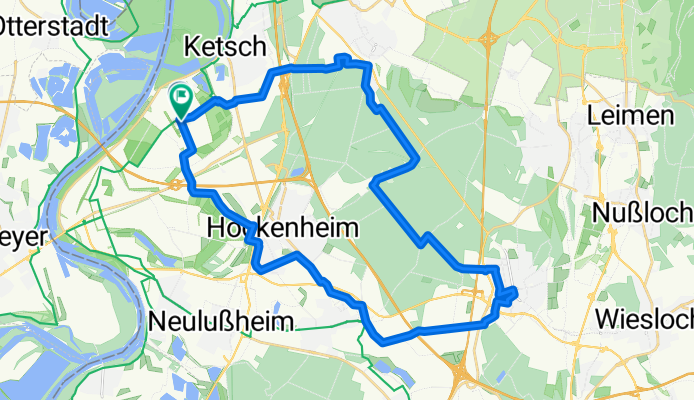
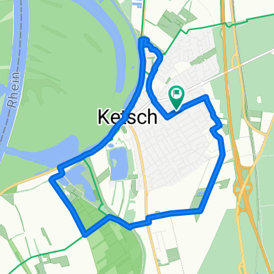
WDF_Johannishof_WDF
A cycling route starting in Ketsch, Baden-Wurttemberg, Germany.
Overview
About this route
- -:--
- Duration
- 34.5 km
- Distance
- 51 m
- Ascent
- 44 m
- Descent
- ---
- Avg. speed
- 118 m
- Max. altitude
Route quality
Waytypes & surfaces along the route
Waytypes
Track
19 km
(55 %)
Quiet road
5.2 km
(15 %)
Surfaces
Paved
29.3 km
(85 %)
Unpaved
4.1 km
(12 %)
Asphalt
26.9 km
(78 %)
Paved (undefined)
1.7 km
(5 %)
Continue with Bikemap
Use, edit, or download this cycling route
You would like to ride WDF_Johannishof_WDF or customize it for your own trip? Here is what you can do with this Bikemap route:
Free features
- Save this route as favorite or in collections
- Copy & plan your own version of this route
- Sync your route with Garmin or Wahoo
Premium features
Free trial for 3 days, or one-time payment. More about Bikemap Premium.
- Navigate this route on iOS & Android
- Export a GPX / KML file of this route
- Create your custom printout (try it for free)
- Download this route for offline navigation
Discover more Premium features.
Get Bikemap PremiumFrom our community
Other popular routes starting in Ketsch
 Ketsch-Speyer
- Distance
- 11.6 km
- Ascent
- 27 m
- Descent
- 23 m
- Location
- Ketsch, Baden-Wurttemberg, Germany
 HM Lauf HRing
- Distance
- 21.1 km
- Ascent
- 67 m
- Descent
- 66 m
- Location
- Ketsch, Baden-Wurttemberg, Germany
 55km Schwein
- Distance
- 55.9 km
- Ascent
- 68 m
- Descent
- 66 m
- Location
- Ketsch, Baden-Wurttemberg, Germany
 Worms, schlecht
- Distance
- 114.3 km
- Ascent
- 73 m
- Descent
- 73 m
- Location
- Ketsch, Baden-Wurttemberg, Germany
 Trainingsrunde flach
- Distance
- 36.5 km
- Ascent
- 56 m
- Descent
- 53 m
- Location
- Ketsch, Baden-Wurttemberg, Germany
 Ketsch Thumbs Up Run
- Distance
- 10.3 km
- Ascent
- 9 m
- Descent
- 13 m
- Location
- Ketsch, Baden-Wurttemberg, Germany
 StLeon
- Distance
- 55.6 km
- Ascent
- 61 m
- Descent
- 59 m
- Location
- Ketsch, Baden-Wurttemberg, Germany
 Johanneshof - Unterhof
- Distance
- 28.1 km
- Ascent
- 94 m
- Descent
- 28 m
- Location
- Ketsch, Baden-Wurttemberg, Germany
Open it in the app