

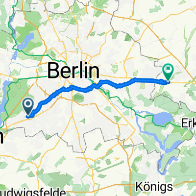
RuW Vorschlag
A cycling route starting in Zehlendorf, State of Berlin, Germany.
Overview
About this route
- 3 h 34 min
- Duration
- 55.4 km
- Distance
- 354 m
- Ascent
- 351 m
- Descent
- 15.6 km/h
- Avg. speed
- 69 m
- Max. altitude

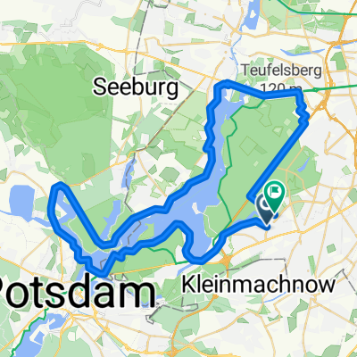
Route highlights
Points of interest along the route
Point of interest after 7.7 km
Flensburger Löwe
Point of interest after 11.6 km
kurzes Stück Kopfsteinpflaster
Point of interest after 14 km
Sacrower Heilandskirche - definitiv einen Stopp wert!
Point of interest after 17.3 km
Meierei im/am Neuen Garten. Biergarten mit schöner Aussicht. Leider oft voll.
Point of interest after 31.8 km
BVG-Fähre zurück nach Wannsee
Point of interest after 53.6 km
Der Fischerhüttenweg hat sehr schlechtes Kopfsteinpflaster!
Continue with Bikemap
Use, edit, or download this cycling route
You would like to ride RuW Vorschlag or customize it for your own trip? Here is what you can do with this Bikemap route:
Free features
- Save this route as favorite or in collections
- Copy & plan your own version of this route
- Sync your route with Garmin or Wahoo
Premium features
Free trial for 3 days, or one-time payment. More about Bikemap Premium.
- Navigate this route on iOS & Android
- Export a GPX / KML file of this route
- Create your custom printout (try it for free)
- Download this route for offline navigation
Discover more Premium features.
Get Bikemap PremiumFrom our community
Other popular routes starting in Zehlendorf
 Hach Lange Radtour Oktober 2008
- Distance
- 50 km
- Ascent
- 194 m
- Descent
- 201 m
- Location
- Zehlendorf, State of Berlin, Germany
 MTB "Just for Fun"
- Distance
- 43.8 km
- Ascent
- 193 m
- Descent
- 192 m
- Location
- Zehlendorf, State of Berlin, Germany
 Onkel-Tom-Straße nach Boll Ensdorfer way
- Distance
- 35.6 km
- Ascent
- 98 m
- Descent
- 97 m
- Location
- Zehlendorf, State of Berlin, Germany
 RuW Vorschlag
- Distance
- 55.4 km
- Ascent
- 354 m
- Descent
- 351 m
- Location
- Zehlendorf, State of Berlin, Germany
 Radtour Südlich von Berlin
- Distance
- 68.2 km
- Ascent
- 117 m
- Descent
- 117 m
- Location
- Zehlendorf, State of Berlin, Germany
 Singener Weg, Berlin nach Schönfließer Straße, Glienicke/Nordbahn
- Distance
- 39.9 km
- Ascent
- 126 m
- Descent
- 116 m
- Location
- Zehlendorf, State of Berlin, Germany
 Berliner Mauerweg
- Distance
- 172.8 km
- Ascent
- 175 m
- Descent
- 181 m
- Location
- Zehlendorf, State of Berlin, Germany
 Z'dorf-Grunewald-Wedding
- Distance
- 15.5 km
- Ascent
- 68 m
- Descent
- 80 m
- Location
- Zehlendorf, State of Berlin, Germany
Open it in the app