

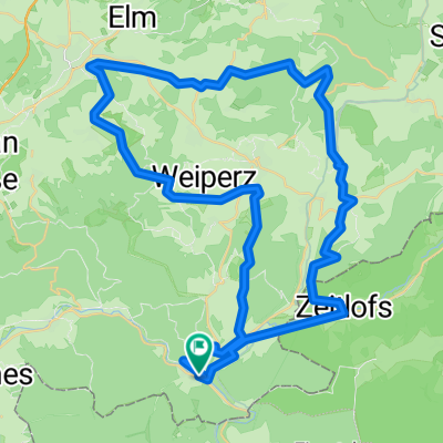
Tour de Bayerisch Schanz
A cycling route starting in Obersinn, Bavaria, Germany.
Overview
About this route
Wir sind von Jossa den Radweg nach Obersinn und Mittelsinn, in Mittelsinn kommt der erste mittelschwere Anstieg nach Aura. Strasse aber geteert. Von Aura nach Fellen, in Fellen dem Schild Bayerische Schanz folgen. Erst ist der Weg geschottert und schön zu fahren. Nach ungefähr einem drittel der Strecke geht es richtig ins Gelände. Dies zieht sich bis zur Bayerischen Schanz dahin. Achtung, die Strecken Beschilderung lässt zu wünschen übrig!!!!
Ab der Bayerischen Schanz geht es dann auf einem schönen geschotterten Weg zurück in Richtung Jossa. Auf diesem Weg immer der Ausschilderung "MB-Strecke" folgen. Kann gar nix schief gehen.
Ab dem Zieglerfeld sind wir dann nicht mehr den Schiledern gefolgt, sondern nach Burgjoss abgebogen und haben den Radweg " Perlen der Jossa " genutzt!
Wechselnder Strassenbelag, sehr viel Feldweg. Am besten mit dem Mountainbike zu fahren!
- -:--
- Duration
- 73.2 km
- Distance
- 1,275 m
- Ascent
- 1,230 m
- Descent
- ---
- Avg. speed
- 543 m
- Max. altitude
Route quality
Waytypes & surfaces along the route
Waytypes
Busy road
28.3 km
(39 %)
Track
25.6 km
(35 %)
Surfaces
Paved
26.8 km
(37 %)
Unpaved
23.9 km
(33 %)
Asphalt
25.6 km
(35 %)
Gravel
21 km
(29 %)
Continue with Bikemap
Use, edit, or download this cycling route
You would like to ride Tour de Bayerisch Schanz or customize it for your own trip? Here is what you can do with this Bikemap route:
Free features
- Save this route as favorite or in collections
- Copy & plan your own version of this route
- Sync your route with Garmin or Wahoo
Premium features
Free trial for 3 days, or one-time payment. More about Bikemap Premium.
- Navigate this route on iOS & Android
- Export a GPX / KML file of this route
- Create your custom printout (try it for free)
- Download this route for offline navigation
Discover more Premium features.
Get Bikemap PremiumFrom our community
Other popular routes starting in Obersinn
 Rhönexpress: Altengronau - Wildflecken
- Distance
- 31.7 km
- Ascent
- 443 m
- Descent
- 133 m
- Location
- Obersinn, Bavaria, Germany
 Obersinn-SLÜ-Fulda-Bad Hersfeld-Kassel-Hann.Münden
- Distance
- 237.6 km
- Ascent
- 530 m
- Descent
- 592 m
- Location
- Obersinn, Bavaria, Germany
 Sinntal Jossa bis Staatsbad Brückenau Rundtour
- Distance
- 38.8 km
- Ascent
- 605 m
- Descent
- 617 m
- Location
- Obersinn, Bavaria, Germany
 Jossa - Bad Brückenau - Bischofsheim
- Distance
- 44.3 km
- Ascent
- 564 m
- Descent
- 344 m
- Location
- Obersinn, Bavaria, Germany
 2009 Jossa-Werntal
- Distance
- 35 km
- Ascent
- 155 m
- Descent
- 245 m
- Location
- Obersinn, Bavaria, Germany
 Climb ´em all
- Distance
- 53.4 km
- Ascent
- 1,030 m
- Descent
- 1,030 m
- Location
- Obersinn, Bavaria, Germany
 2013 Jossa-Morlesau (Sinntal-Fränkische Saale)
- Distance
- 55.4 km
- Ascent
- 201 m
- Descent
- 239 m
- Location
- Obersinn, Bavaria, Germany
 Tour de Bayerisch Schanz
- Distance
- 73.2 km
- Ascent
- 1,275 m
- Descent
- 1,230 m
- Location
- Obersinn, Bavaria, Germany
Open it in the app