

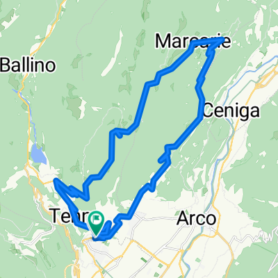
Od Lago di Tenno přes Riva del Garda do Nago-Torbole
A cycling route starting in Tenno, Trentino-Alto Adige, Italy.
Overview
About this route
Easy route with a tour of the town of Riva del Garda.
- -:--
- Duration
- 17.9 km
- Distance
- 262 m
- Ascent
- 628 m
- Descent
- ---
- Avg. speed
- ---
- Max. altitude
Route highlights
Points of interest along the route

Photo after 1.6 km
Pranzo,vzadu Tenno

Photo after 3.3 km
Ville del Monte

Photo after 4.1 km
Tenno

Photo after 5.9 km
Riva del Garda

Photo after 9.7 km
Riva del Garda-Porta San Marco

Photo after 10.1 km
Riva del Garda-Piazza Garibaldi

Photo after 12.4 km
Riva del Garda-Porto San Nicolo

Photo after 14 km
vtok Sarca do Lago di Garda

Photo after 15.6 km
Nago-Torbole a Lago di Garda

Photo after 16.6 km
stoupání do Nago

Photo after 16.8 km
Nago
Continue with Bikemap
Use, edit, or download this cycling route
You would like to ride Od Lago di Tenno přes Riva del Garda do Nago-Torbole or customize it for your own trip? Here is what you can do with this Bikemap route:
Free features
- Save this route as favorite or in collections
- Copy & plan your own version of this route
- Sync your route with Garmin or Wahoo
Premium features
Free trial for 3 days, or one-time payment. More about Bikemap Premium.
- Navigate this route on iOS & Android
- Export a GPX / KML file of this route
- Create your custom printout (try it for free)
- Download this route for offline navigation
Discover more Premium features.
Get Bikemap PremiumFrom our community
Other popular routes starting in Tenno
 Od Lago di Tenno přes Riva del Garda do Nago-Torbole
- Distance
- 17.9 km
- Ascent
- 262 m
- Descent
- 628 m
- Location
- Tenno, Trentino-Alto Adige, Italy
 Recording from 7 Dicembre 11:28
- Distance
- 3.8 km
- Ascent
- 146 m
- Descent
- 109 m
- Location
- Tenno, Trentino-Alto Adige, Italy
 Riva Del Garda Road Bike
- Distance
- 87.9 km
- Ascent
- 844 m
- Descent
- 844 m
- Location
- Tenno, Trentino-Alto Adige, Italy
 Strada Statale nach Strada Statale
- Distance
- 12.7 km
- Ascent
- 567 m
- Descent
- 567 m
- Location
- Tenno, Trentino-Alto Adige, Italy
 Vrchařská prémie na Mt. Misone
- Distance
- 21.8 km
- Ascent
- 1,257 m
- Descent
- 1,245 m
- Location
- Tenno, Trentino-Alto Adige, Italy
 Tenno - St.Giovany - Tenno (2)
- Distance
- 24.8 km
- Ascent
- 955 m
- Descent
- 955 m
- Location
- Tenno, Trentino-Alto Adige, Italy
 Gavazzo - San Giovanni - Calvola
- Distance
- 31.8 km
- Ascent
- 1,496 m
- Descent
- 1,478 m
- Location
- Tenno, Trentino-Alto Adige, Italy
 I_Tenno-Calvola-um Monte San Pietro-Treni_15km-550hm-LL
- Distance
- 14.6 km
- Ascent
- 517 m
- Descent
- 519 m
- Location
- Tenno, Trentino-Alto Adige, Italy
Open it in the app