

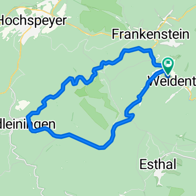
2012 Saupferch-Drachenfels
A cycling route starting in Weidenthal, Rhineland-Palatinate, Germany.
Overview
About this route
ab parkplatz Saupferch
NUR HOCH!
ohne karte oder irgendein plan,perfekt hingefunden
erst am freidrichsbrunnen das erste drachenfels schild gesehen!
ne gute stunde mit pause am brunnen
und 20 minuten für die abfahrt!,mit mountainbike wahrscheinlich nur 5 minuten
auf groben strassen oder aufgeweichten wegen und ab etwa friedrichsbrunnen auf wanderweg,erstaunlicherweise bis zur spitzkehre am fuß des felsen auf rennlenkerrad geschafft
100% mountainbike gelände!
der ausblick besonders vom südfelsen ist nicht mehr zu toppen!!!!
der absolute kick,Sommerhitze,perfekte weitsicht über den halben Pfälzerwald,über den bäumen,im geruch der kiefern,da könnte ich wochen bleiben da oben
während der woche nahezu nichts los da oben
DER WEG LOHNT SICH!!!
und zurück versteht sich
- -:--
- Duration
- 5.8 km
- Distance
- 363 m
- Ascent
- 82 m
- Descent
- ---
- Avg. speed
- ---
- Max. altitude
Route highlights
Points of interest along the route
Point of interest after 3.7 km
friedrichsbrunnen,WASSER und dusche! ab da auf wanderweg blaue strich
Continue with Bikemap
Use, edit, or download this cycling route
You would like to ride 2012 Saupferch-Drachenfels or customize it for your own trip? Here is what you can do with this Bikemap route:
Free features
- Save this route as favorite or in collections
- Copy & plan your own version of this route
- Sync your route with Garmin or Wahoo
Premium features
Free trial for 3 days, or one-time payment. More about Bikemap Premium.
- Navigate this route on iOS & Android
- Export a GPX / KML file of this route
- Create your custom printout (try it for free)
- Download this route for offline navigation
Discover more Premium features.
Get Bikemap PremiumFrom our community
Other popular routes starting in Weidenthal
 Saupferch - Drachenfels
- Distance
- 15.9 km
- Ascent
- 570 m
- Descent
- 576 m
- Location
- Weidenthal, Rhineland-Palatinate, Germany
 NW - Eiswoog - NW
- Distance
- 65.5 km
- Ascent
- 722 m
- Descent
- 735 m
- Location
- Weidenthal, Rhineland-Palatinate, Germany
 Drachenfels - Neustadt
- Distance
- 17.6 km
- Ascent
- 208 m
- Descent
- 626 m
- Location
- Weidenthal, Rhineland-Palatinate, Germany
 B39 Morschbacherhof Esthal Breitenstein
- Distance
- 11.8 km
- Ascent
- 305 m
- Descent
- 336 m
- Location
- Weidenthal, Rhineland-Palatinate, Germany
 Leinbachtal RW Start Weidenthal
- Distance
- 22.6 km
- Ascent
- 658 m
- Descent
- 656 m
- Location
- Weidenthal, Rhineland-Palatinate, Germany
 2012 Saupferch-Drachenfels
- Distance
- 5.8 km
- Ascent
- 363 m
- Descent
- 82 m
- Location
- Weidenthal, Rhineland-Palatinate, Germany
 Tageswanderung Drachenfels
- Distance
- 14.9 km
- Ascent
- 476 m
- Descent
- 517 m
- Location
- Weidenthal, Rhineland-Palatinate, Germany
 Runde um den Erlenkopf
- Distance
- 103.1 km
- Ascent
- 2,346 m
- Descent
- 2,383 m
- Location
- Weidenthal, Rhineland-Palatinate, Germany
Open it in the app