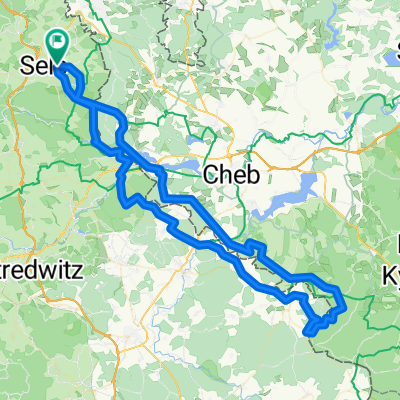
1.Mai Tour
A cycling route starting in Selb, Bavaria, Germany.
Overview
About this route
- -:--
- Duration
- 36.3 km
- Distance
- 600 m
- Ascent
- 606 m
- Descent
- ---
- Avg. speed
- 792 m
- Avg. speed
Route quality
Waytypes & surfaces along the route
Waytypes
Track
19.1 km
(53 %)
Quiet road
12.2 km
(33 %)
Surfaces
Paved
5.2 km
(14 %)
Unpaved
20.7 km
(57 %)
Gravel
15.1 km
(42 %)
Ground
3.3 km
(9 %)
Route highlights
Points of interest along the route
Point of interest after 9.5 km
Waldgaststätte "Altes Pfarrhaus" mit Biergarten
Point of interest after 16.2 km
Burgruine Hirschstein
Point of interest after 32.6 km
Meilerplatz
Continue with Bikemap
Use, edit, or download this cycling route
You would like to ride 1.Mai Tour or customize it for your own trip? Here is what you can do with this Bikemap route:
Free features
- Save this route as favorite or in collections
- Copy & plan your own version of this route
- Sync your route with Garmin or Wahoo
Premium features
Free trial for 3 days, or one-time payment. More about Bikemap Premium.
- Navigate this route on iOS & Android
- Export a GPX / KML file of this route
- Create your custom printout (try it for free)
- Download this route for offline navigation
Discover more Premium features.
Get Bikemap PremiumFrom our community
Other popular routes starting in Selb
- Teiche um Selb
- Distance
- 14.7 km
- Ascent
- 151 m
- Descent
- 157 m
- Location
- Selb, Bavaria, Germany
- Wellertal- Historische Grenzsteine
- Distance
- 31 km
- Ascent
- 324 m
- Descent
- 326 m
- Location
- Selb, Bavaria, Germany
- 16K Weißenbach_Rondell_Kaiserhammer_Weißenbach
- Distance
- 16.2 km
- Ascent
- 246 m
- Descent
- 249 m
- Location
- Selb, Bavaria, Germany
- wunsiedelrunde_rr
- Distance
- 63.1 km
- Ascent
- 433 m
- Descent
- 433 m
- Location
- Selb, Bavaria, Germany
- ADFC-Wochenendausfahrt - nur Rückfahrt vom Meilerfest in Sel b
- Distance
- 39.1 km
- Ascent
- 321 m
- Descent
- 387 m
- Location
- Selb, Bavaria, Germany
- SelbThiersteinHendelhammer
- Distance
- 22.4 km
- Ascent
- 243 m
- Descent
- 245 m
- Location
- Selb, Bavaria, Germany
- Selb-Kirchenlamitz
- Distance
- 17.9 km
- Ascent
- 239 m
- Descent
- 196 m
- Location
- Selb, Bavaria, Germany
- Selb-Tillenberg
- Distance
- 92.2 km
- Ascent
- 1,381 m
- Descent
- 1,419 m
- Location
- Selb, Bavaria, Germany
Open it in the app