![Szlak ŻÓŁTY (gmina Jastków) - obwodnica [???]](/_next/static/media/contour-lines-light-small.cafd5e5d.avif)
![Szlak ŻÓŁTY (gmina Jastków) - obwodnica [???]](https://media.bikemap.net/routes/1688589/staticmaps/in_d052a8b4-bfcb-4506-b64e-ef2a75999757_694x400_bikemap-2021-3D-static.png)
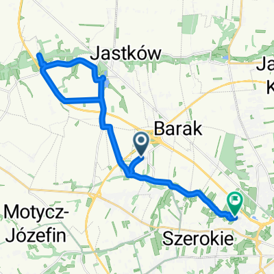
Szlak ŻÓŁTY (gmina Jastków) - obwodnica [???]
A cycling route starting in Jastków, Lublin Voivodeship, Poland.
Overview
About this route
- -:--
- Duration
- 34.3 km
- Distance
- 120 m
- Ascent
- 120 m
- Descent
- ---
- Avg. speed
- ---
- Max. altitude

Route highlights
Points of interest along the route
Point of interest after 11.7 km
Bida
Point of interest after 12.6 km
Gdzieś tu obwodnica...
Point of interest after 13.6 km
Ślepa w lewo
Point of interest after 19.2 km
Skręcić w lewo, następne w lewo...
Point of interest after 28.5 km
[Tomaszowice] Jechać prosto, następne w lewo...
Point of interest after 30.5 km
W lewo c. d. ŻÓŁTEGO
Continue with Bikemap
Use, edit, or download this cycling route
You would like to ride Szlak ŻÓŁTY (gmina Jastków) - obwodnica [???] or customize it for your own trip? Here is what you can do with this Bikemap route:
Free features
- Save this route as favorite or in collections
- Copy & plan your own version of this route
- Sync your route with Garmin or Wahoo
Premium features
Free trial for 3 days, or one-time payment. More about Bikemap Premium.
- Navigate this route on iOS & Android
- Export a GPX / KML file of this route
- Create your custom printout (try it for free)
- Download this route for offline navigation
Discover more Premium features.
Get Bikemap PremiumFrom our community
Other popular routes starting in Jastków
 Lasy Kozłowieckie
- Distance
- 31.7 km
- Ascent
- 117 m
- Descent
- 117 m
- Location
- Jastków, Lublin Voivodeship, Poland
 Tomaszowice - Jastków - Sieprawice - Ługów - Gutanów - Garbów - Moszenki - Tomaszowice
- Distance
- 40.6 km
- Ascent
- 184 m
- Descent
- 184 m
- Location
- Jastków, Lublin Voivodeship, Poland
 szlak niebieski gmina Jastków
- Distance
- 46 km
- Ascent
- 298 m
- Descent
- 298 m
- Location
- Jastków, Lublin Voivodeship, Poland
 Dąbrowica do Opolan 30, Lublin
- Distance
- 18.9 km
- Ascent
- 127 m
- Descent
- 149 m
- Location
- Jastków, Lublin Voivodeship, Poland
 2 wersja pętli szosowej
- Distance
- 87.8 km
- Ascent
- 192 m
- Descent
- 246 m
- Location
- Jastków, Lublin Voivodeship, Poland
 Szlak Jastków- wariant ominięcia wąwozu
- Distance
- 2.8 km
- Ascent
- 41 m
- Descent
- 5 m
- Location
- Jastków, Lublin Voivodeship, Poland
 prawdziwe Mtb
- Distance
- 55.1 km
- Ascent
- 170 m
- Descent
- 173 m
- Location
- Jastków, Lublin Voivodeship, Poland
![Szlak ŻÓŁTY (gmina Jastków) - obwodnica [???]](https://media.bikemap.net/routes/1688589/staticmaps/in_d052a8b4-bfcb-4506-b64e-ef2a75999757_400x400_bikemap-2021-3D-static.png) Szlak ŻÓŁTY (gmina Jastków) - obwodnica [???]
Szlak ŻÓŁTY (gmina Jastków) - obwodnica [???]- Distance
- 34.3 km
- Ascent
- 120 m
- Descent
- 120 m
- Location
- Jastków, Lublin Voivodeship, Poland
Open it in the app