
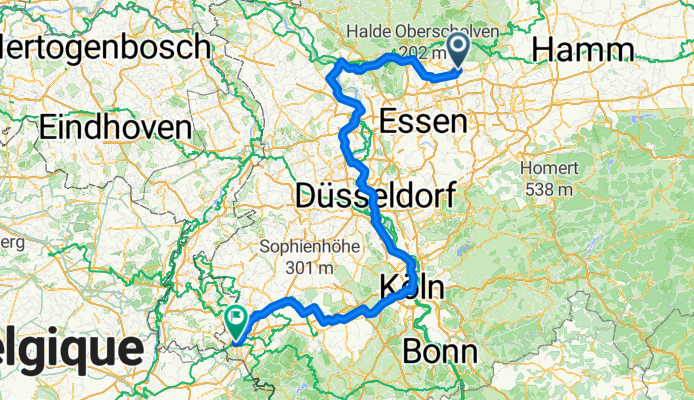
Rhein
A cycling route starting in Recklinghausen, North Rhine-Westphalia, Germany.
Overview
About this route
- 14 h 37 min
- Duration
- 252.5 km
- Distance
- 714 m
- Ascent
- 640 m
- Descent
- 17.3 km/h
- Avg. speed
- 194 m
- Max. altitude

Route quality
Waytypes & surfaces along the route
Waytypes
Path
164.1 km
(65 %)
Quiet road
37.9 km
(15 %)
Surfaces
Paved
174.2 km
(69 %)
Unpaved
10.1 km
(4 %)
Asphalt
159.1 km
(63 %)
Paved (undefined)
15.1 km
(6 %)
Continue with Bikemap
Use, edit, or download this cycling route
You would like to ride Rhein or customize it for your own trip? Here is what you can do with this Bikemap route:
Free features
- Save this route as favorite or in collections
- Copy & plan your own version of this route
- Split it into stages to create a multi-day tour
- Sync your route with Garmin or Wahoo
Premium features
Free trial for 3 days, or one-time payment. More about Bikemap Premium.
- Navigate this route on iOS & Android
- Export a GPX / KML file of this route
- Create your custom printout (try it for free)
- Download this route for offline navigation
Discover more Premium features.
Get Bikemap PremiumFrom our community
Other popular routes starting in Recklinghausen
 Recklinghausen Runde
- Distance
- 38.7 km
- Ascent
- 205 m
- Descent
- 202 m
- Location
- Recklinghausen, North Rhine-Westphalia, Germany
 Buchi's Runde
- Distance
- 58.8 km
- Ascent
- 321 m
- Descent
- 314 m
- Location
- Recklinghausen, North Rhine-Westphalia, Germany
 Rhein
Rhein- Distance
- 252.5 km
- Ascent
- 714 m
- Descent
- 640 m
- Location
- Recklinghausen, North Rhine-Westphalia, Germany
 In den Heuwiesen 34, Recklinghausen nach Blitzkuhlenstraße 123, Recklinghausen
- Distance
- 34.8 km
- Ascent
- 145 m
- Descent
- 159 m
- Location
- Recklinghausen, North Rhine-Westphalia, Germany
 Halterner Straße 16, Marl nach Halterner Straße 16, Marl
- Distance
- 30.2 km
- Ascent
- 328 m
- Descent
- 327 m
- Location
- Recklinghausen, North Rhine-Westphalia, Germany
 D - Recklinghausen - Rund um Recklinghausen (WAZ 10) - 43 km
- Distance
- 42.5 km
- Ascent
- 193 m
- Descent
- 193 m
- Location
- Recklinghausen, North Rhine-Westphalia, Germany
 Von RE zum Rundkurs Unser-Fritz Ruhr nach Essen
- Distance
- 70.3 km
- Ascent
- 252 m
- Descent
- 249 m
- Location
- Recklinghausen, North Rhine-Westphalia, Germany
 Rund um den Halterner See
- Distance
- 54.3 km
- Ascent
- 196 m
- Descent
- 202 m
- Location
- Recklinghausen, North Rhine-Westphalia, Germany
Open it in the app