

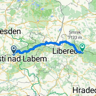
Lehčí výlet
A cycling route starting in Chlumec, Ústecký kraj, Czechia.
Overview
About this route
- -:--
- Duration
- 35.4 km
- Distance
- 410 m
- Ascent
- 766 m
- Descent
- ---
- Avg. speed
- 755 m
- Max. altitude
Route quality
Waytypes & surfaces along the route
Waytypes
Road
19.8 km
(56 %)
Track
6 km
(17 %)
Surfaces
Paved
25.5 km
(72 %)
Unpaved
4.2 km
(12 %)
Asphalt
24.7 km
(70 %)
Unpaved (undefined)
3.9 km
(11 %)
Continue with Bikemap
Use, edit, or download this cycling route
You would like to ride Lehčí výlet or customize it for your own trip? Here is what you can do with this Bikemap route:
Free features
- Save this route as favorite or in collections
- Copy & plan your own version of this route
- Sync your route with Garmin or Wahoo
Premium features
Free trial for 3 days, or one-time payment. More about Bikemap Premium.
- Navigate this route on iOS & Android
- Export a GPX / KML file of this route
- Create your custom printout (try it for free)
- Download this route for offline navigation
Discover more Premium features.
Get Bikemap PremiumFrom our community
Other popular routes starting in Chlumec
 Adolfov - Bar Hamburg
- Distance
- 32.3 km
- Ascent
- 205 m
- Descent
- 808 m
- Location
- Chlumec, Ústecký kraj, Czechia
 Adolfov (Adolfsgrün) - Harrachov (Harrachsdorf)
- Distance
- 153.9 km
- Ascent
- 1,491 m
- Descent
- 1,475 m
- Location
- Chlumec, Ústecký kraj, Czechia
 Lehčí výlet
- Distance
- 35.4 km
- Ascent
- 410 m
- Descent
- 766 m
- Location
- Chlumec, Ústecký kraj, Czechia
 Adolfov-Decin-Usti v4
- Distance
- 63.4 km
- Ascent
- 206 m
- Descent
- 779 m
- Location
- Chlumec, Ústecký kraj, Czechia
 Přes Německo zpět do Chlumce
- Distance
- 95.5 km
- Ascent
- 968 m
- Descent
- 968 m
- Location
- Chlumec, Ústecký kraj, Czechia
 Chlumec - Krupka - Chabařovice
- Distance
- 26.2 km
- Ascent
- 141 m
- Descent
- 142 m
- Location
- Chlumec, Ústecký kraj, Czechia
 Chlumec - Drážďany (Zwinger) - Chlumec 112 km
- Distance
- 56.1 km
- Ascent
- 636 m
- Descent
- 780 m
- Location
- Chlumec, Ústecký kraj, Czechia
 Kulm - Slavětín
- Distance
- 60.2 km
- Ascent
- 547 m
- Descent
- 582 m
- Location
- Chlumec, Ústecký kraj, Czechia
Open it in the app