

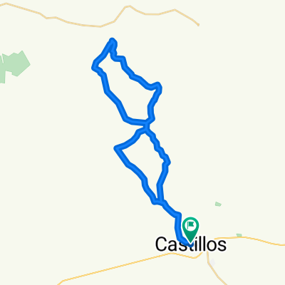
BAJADA MALA - HOMBRES
A cycling route starting in Castillos, Rocha Department, Uruguay.
Overview
About this route
- -:--
- Duration
- 50.5 km
- Distance
- 465 m
- Ascent
- 465 m
- Descent
- ---
- Avg. speed
- ---
- Max. altitude
Route highlights
Points of interest along the route
Point of interest after 35.3 km
DESVIO CATEGORIA HOMBRES
Continue with Bikemap
Use, edit, or download this cycling route
You would like to ride BAJADA MALA - HOMBRES or customize it for your own trip? Here is what you can do with this Bikemap route:
Free features
- Save this route as favorite or in collections
- Copy & plan your own version of this route
- Sync your route with Garmin or Wahoo
Premium features
Free trial for 3 days, or one-time payment. More about Bikemap Premium.
- Navigate this route on iOS & Android
- Export a GPX / KML file of this route
- Create your custom printout (try it for free)
- Download this route for offline navigation
Discover more Premium features.
Get Bikemap PremiumFrom our community
Other popular routes starting in Castillos
 Ruta 16 - Fransisco de los Santos/Camino de los Indios
- Distance
- 49.2 km
- Ascent
- 426 m
- Descent
- 395 m
- Location
- Castillos, Rocha Department, Uruguay
 De M. González 8, Sección 04 a Luis Fabregat, Sección 04
- Distance
- 17.6 km
- Ascent
- 249 m
- Descent
- 254 m
- Location
- Castillos, Rocha Department, Uruguay
 BAJADA MALA 2013
- Distance
- 62.2 km
- Ascent
- 603 m
- Descent
- 600 m
- Location
- Castillos, Rocha Department, Uruguay
 Arenas Doradas 452, Aguas Dulces a Arenas Doradas 976, Aguas Dulces
- Distance
- 2.1 km
- Ascent
- 0 m
- Descent
- 0 m
- Location
- Castillos, Rocha Department, Uruguay
 BAJADA MALA
- Distance
- 39.7 km
- Ascent
- 434 m
- Descent
- 434 m
- Location
- Castillos, Rocha Department, Uruguay
 Ruta supersónica en Sección 04
- Distance
- 10.7 km
- Ascent
- 110 m
- Descent
- 65 m
- Location
- Castillos, Rocha Department, Uruguay
 BAJADA MALA - HOMBRES
- Distance
- 50.5 km
- Ascent
- 465 m
- Descent
- 465 m
- Location
- Castillos, Rocha Department, Uruguay
 De ¿èNÿ? a ¿èNÿ?
- Distance
- 16.9 km
- Ascent
- 100 m
- Descent
- 120 m
- Location
- Castillos, Rocha Department, Uruguay
Open it in the app