

Łańcut do Ks J Forysiewicza, Głogów Małopolski
A cycling route starting in Łańcut, Subcarpathian Voivodeship, Poland.
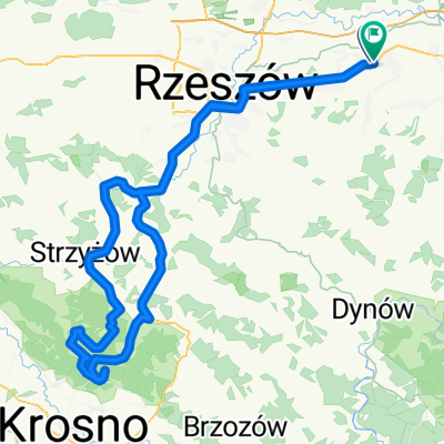
Overview
About this route
- 3 h 10 min
- Duration
- 32.5 km
- Distance
- 148 m
- Ascent
- 158 m
- Descent
- 10.2 km/h
- Avg. speed
- 248 m
- Max. altitude
Route photos


Route quality
Waytypes & surfaces along the route
Waytypes
Quiet road
12.4 km
(38 %)
Path
7.2 km
(22 %)
Surfaces
Paved
25.7 km
(79 %)
Unpaved
4.2 km
(13 %)
Asphalt
20.2 km
(62 %)
Paved (undefined)
5.5 km
(17 %)
Continue with Bikemap
Use, edit, or download this cycling route
You would like to ride Łańcut do Ks J Forysiewicza, Głogów Małopolski or customize it for your own trip? Here is what you can do with this Bikemap route:
Free features
- Save this route as favorite or in collections
- Copy & plan your own version of this route
- Sync your route with Garmin or Wahoo
Premium features
Free trial for 3 days, or one-time payment. More about Bikemap Premium.
- Navigate this route on iOS & Android
- Export a GPX / KML file of this route
- Create your custom printout (try it for free)
- Download this route for offline navigation
Discover more Premium features.
Get Bikemap PremiumFrom our community
Other popular routes starting in Łańcut
 Bieszczady 2012 - Majówka
- Distance
- 333.4 km
- Ascent
- 1,504 m
- Descent
- 1,536 m
- Location
- Łańcut, Subcarpathian Voivodeship, Poland
 Siódma duża trasa 2013
- Distance
- 104.5 km
- Ascent
- 745 m
- Descent
- 740 m
- Location
- Łańcut, Subcarpathian Voivodeship, Poland
 Łańcut-Gorzejowa
- Distance
- 78.6 km
- Ascent
- 608 m
- Descent
- 465 m
- Location
- Łańcut, Subcarpathian Voivodeship, Poland
 Standardzik na 30 km
- Distance
- 31.7 km
- Ascent
- 178 m
- Descent
- 178 m
- Location
- Łańcut, Subcarpathian Voivodeship, Poland
 Na niedzielę
- Distance
- 125 km
- Ascent
- 780 m
- Descent
- 815 m
- Location
- Łańcut, Subcarpathian Voivodeship, Poland
 Sucha Góra - planowana
- Distance
- 142.2 km
- Ascent
- 678 m
- Descent
- 687 m
- Location
- Łańcut, Subcarpathian Voivodeship, Poland
 bonnesoiree07072015
- Distance
- 57.1 km
- Ascent
- 658 m
- Descent
- 655 m
- Location
- Łańcut, Subcarpathian Voivodeship, Poland
 Sonina Markowa Hubert Zabratówka Handzlówka
- Distance
- 46.4 km
- Ascent
- 436 m
- Descent
- 435 m
- Location
- Łańcut, Subcarpathian Voivodeship, Poland
Open it in the app