
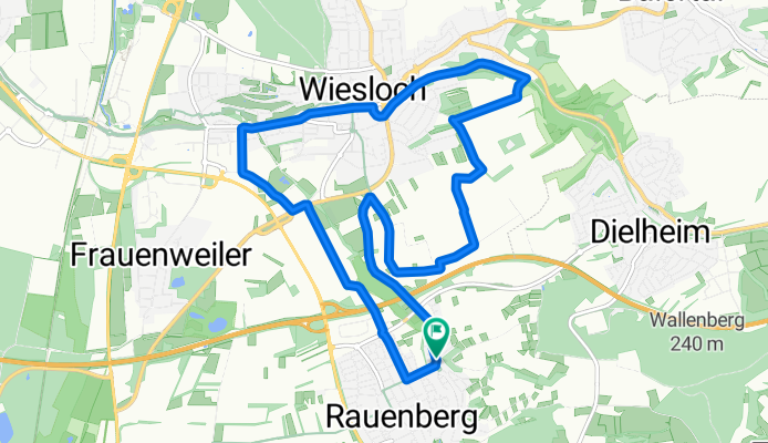
Rauenberg - Wiesloch Weinberge
A cycling route starting in Rauenberg, Baden-Wurttemberg, Germany.
Overview
About this route
Tour from Rauenberg to Winzerkeller Wiesloch - through the vineyards to the animal shelter. On the old railway embankment up to the town hall - then through Schwetzinger Street - passing by the swimming pool back to Rauenberg.
- -:--
- Duration
- 12 km
- Distance
- 79 m
- Ascent
- 80 m
- Descent
- ---
- Avg. speed
- 171 m
- Max. altitude

Route quality
Waytypes & surfaces along the route
Waytypes
Track
5.5 km
(46 %)
Quiet road
3.2 km
(27 %)
Surfaces
Paved
10.3 km
(86 %)
Unpaved
0.6 km
(5 %)
Asphalt
10.1 km
(84 %)
Gravel
0.6 km
(5 %)
Continue with Bikemap
Use, edit, or download this cycling route
You would like to ride Rauenberg - Wiesloch Weinberge or customize it for your own trip? Here is what you can do with this Bikemap route:
Free features
- Save this route as favorite or in collections
- Copy & plan your own version of this route
- Sync your route with Garmin or Wahoo
Premium features
Free trial for 3 days, or one-time payment. More about Bikemap Premium.
- Navigate this route on iOS & Android
- Export a GPX / KML file of this route
- Create your custom printout (try it for free)
- Download this route for offline navigation
Discover more Premium features.
Get Bikemap PremiumFrom our community
Other popular routes starting in Rauenberg
 Rauenberg - Flugplatzrunde
- Distance
- 23.1 km
- Ascent
- 122 m
- Descent
- 132 m
- Location
- Rauenberg, Baden-Wurttemberg, Germany
 Rauenberg - Königstuhl1
- Distance
- 49.9 km
- Ascent
- 578 m
- Descent
- 576 m
- Location
- Rauenberg, Baden-Wurttemberg, Germany
 Kraichgauroute Rauenberg-Eschelbach-Rauenberg
- Distance
- 20.2 km
- Ascent
- 161 m
- Descent
- 159 m
- Location
- Rauenberg, Baden-Wurttemberg, Germany
 Rauenberg - Wiesloch Weinberge
- Distance
- 12 km
- Ascent
- 79 m
- Descent
- 80 m
- Location
- Rauenberg, Baden-Wurttemberg, Germany
 Rauenberg - Schatthausen -Oberhof Runde
- Distance
- 19.8 km
- Ascent
- 206 m
- Descent
- 202 m
- Location
- Rauenberg, Baden-Wurttemberg, Germany
 Rauenberg - kurze Frauenweiler Runde
- Distance
- 10.2 km
- Ascent
- 34 m
- Descent
- 41 m
- Location
- Rauenberg, Baden-Wurttemberg, Germany
 Angelbachtal
- Distance
- 43.9 km
- Ascent
- 273 m
- Descent
- 273 m
- Location
- Rauenberg, Baden-Wurttemberg, Germany
 Rauenberg kurze Mannaberg Runde
- Distance
- 3.6 km
- Ascent
- 85 m
- Descent
- 84 m
- Location
- Rauenberg, Baden-Wurttemberg, Germany
Open it in the app