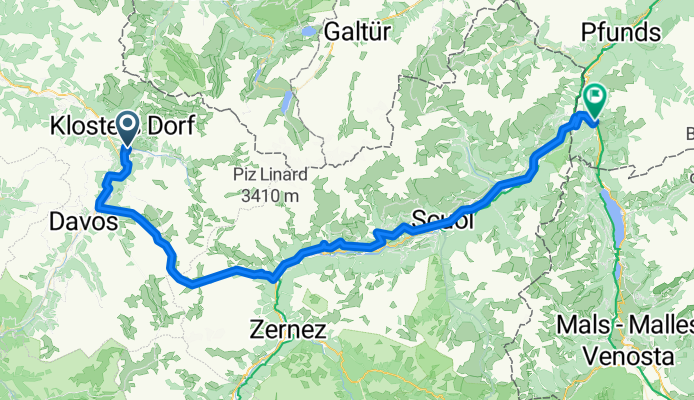
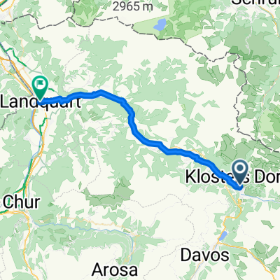
Klosters to Nauders
A cycling route starting in Klosters Serneus, Grisons, Switzerland.
Overview
About this route
- 5 h 14 min
- Duration
- 85.8 km
- Distance
- 3,100 m
- Ascent
- 2,928 m
- Descent
- 16.4 km/h
- Avg. speed
- 2,395 m
- Max. altitude
Route photos
Route quality
Waytypes & surfaces along the route
Waytypes
Road
14.8 km
(17 %)
Quiet road
9.6 km
(11 %)
Surfaces
Paved
59.8 km
(70 %)
Unpaved
2.7 km
(3 %)
Asphalt
57.3 km
(67 %)
Loose gravel
2.7 km
(3 %)
Route highlights
Points of interest along the route
Point of interest after 17.4 km
Photopoint
Point of interest after 21.6 km
Flüelapass 12.9km 823m climb 6.4% av 10% max 2383m elevation
Point of interest after 35.6 km
Fortezza Rohan
Point of interest after 40.3 km
Ruinas da Gonda On the old Via Engiadina, between Lavin and Guarda, lie the remains of the Gonda settlement. In addition to the partially rebuilt chapel, the view of the remaining walls of a very large house is particularly impressive. The inhabitants apparently abandoned this site in 16??, and the houses and terraces fell into disrepair over the centuries.
Point of interest after 43 km
Jordankeramik ceramic art gallery 2-5
Point of interest after 43.3 km
Guard'Art art gallery
Point of interest after 48.1 km
Chastè Steinsberg
Point of interest after 49.2 km
Ruine Chanoua (Ruina Chanoua)
Point of interest after 56.3 km
Schloss Tarasp Built in the 11th century, this hilltop castle features a restored interior with antique furniture.
Point of interest after 62.2 km
Rablönch-Quelle mineral spring with arsenic level a little above acceptable (26 vs 10 ppb). Accounts for orange colour in runoff area.
Point of interest after 68 km
Burg Tschanüff
Continue with Bikemap
Use, edit, or download this cycling route
You would like to ride Klosters to Nauders or customize it for your own trip? Here is what you can do with this Bikemap route:
Free features
- Save this route as favorite or in collections
- Copy & plan your own version of this route
- Split it into stages to create a multi-day tour
- Sync your route with Garmin or Wahoo
Premium features
Free trial for 3 days, or one-time payment. More about Bikemap Premium.
- Navigate this route on iOS & Android
- Export a GPX / KML file of this route
- Create your custom printout (try it for free)
- Download this route for offline navigation
Discover more Premium features.
Get Bikemap PremiumFrom our community
Other popular routes starting in Klosters Serneus
- tret-lager.ch 2014, 5. Etappe Kloster - Rämismühle
- Distance
- 140 km
- Ascent
- 690 m
- Descent
- 1,338 m
- Location
- Klosters Serneus, Grisons, Switzerland
- 21 Prättigauer Route Radweg von Klosters nach Sargans
- Distance
- 47.8 km
- Ascent
- 345 m
- Descent
- 1,054 m
- Location
- Klosters Serneus, Grisons, Switzerland
- Einfache Fahrt in Klosters
- Distance
- 13.1 km
- Ascent
- 852 m
- Descent
- 849 m
- Location
- Klosters Serneus, Grisons, Switzerland
- Langsame Fahrt in Klosters
- Distance
- 22.5 km
- Ascent
- 775 m
- Descent
- 780 m
- Location
- Klosters Serneus, Grisons, Switzerland
- 330 Panorama Ride
- Distance
- 121.7 km
- Ascent
- 6,791 m
- Descent
- 6,791 m
- Location
- Klosters Serneus, Grisons, Switzerland
- Klosters to Nauders
- Distance
- 85.8 km
- Ascent
- 3,100 m
- Descent
- 2,928 m
- Location
- Klosters Serneus, Grisons, Switzerland
- Panoramaweg (Gotschnagrat - Davos Platz)
- Distance
- 16 km
- Ascent
- 283 m
- Descent
- 1,008 m
- Location
- Klosters Serneus, Grisons, Switzerland
- 21 Prättigauer Route Radweg von Klosters nach Sargans
- Distance
- 47.8 km
- Ascent
- 0 m
- Descent
- 0 m
- Location
- Klosters Serneus, Grisons, Switzerland
Open it in the app