

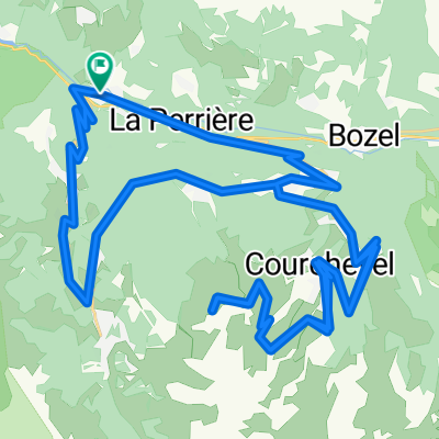
G2N DAY 3: LES ALLUES to VALLOIRE
A cycling route starting in Les Allues, Auvergne-Rhône-Alpes, France.
Overview
About this route
Col de la MadelieneLacets des MontvernierCol du Télégraphe - Col de la MadelieneLacets des MontvernierCol du Télégraphe
- -:--
- Duration
- 113.3 km
- Distance
- 3,145 m
- Ascent
- 2,858 m
- Descent
- ---
- Avg. speed
- 1,989 m
- Max. altitude

Continue with Bikemap
Use, edit, or download this cycling route
You would like to ride G2N DAY 3: LES ALLUES to VALLOIRE or customize it for your own trip? Here is what you can do with this Bikemap route:
Free features
- Save this route as favorite or in collections
- Copy & plan your own version of this route
- Split it into stages to create a multi-day tour
- Sync your route with Garmin or Wahoo
Premium features
Free trial for 3 days, or one-time payment. More about Bikemap Premium.
- Navigate this route on iOS & Android
- Export a GPX / KML file of this route
- Create your custom printout (try it for free)
- Download this route for offline navigation
Discover more Premium features.
Get Bikemap PremiumFrom our community
Other popular routes starting in Les Allues
 Col de la Loze
- Distance
- 51.4 km
- Ascent
- 1,699 m
- Descent
- 1,704 m
- Location
- Les Allues, Auvergne-Rhône-Alpes, France
 etape_17_meribel
- Distance
- 14.8 km
- Ascent
- 1,149 m
- Descent
- 0 m
- Location
- Les Allues, Auvergne-Rhône-Alpes, France
 Z4 - Col de la Loze si La Tania
- Distance
- 63.4 km
- Ascent
- 1,829 m
- Descent
- 1,828 m
- Location
- Les Allues, Auvergne-Rhône-Alpes, France
 Meribel via
- Distance
- 42.2 km
- Ascent
- 1,194 m
- Descent
- 1,196 m
- Location
- Les Allues, Auvergne-Rhône-Alpes, France
 Meribel Loop
- Distance
- 32.9 km
- Ascent
- 1,024 m
- Descent
- 1,024 m
- Location
- Les Allues, Auvergne-Rhône-Alpes, France
 SC Cdla Loze
- Distance
- 46.6 km
- Ascent
- 1,691 m
- Descent
- 1,449 m
- Location
- Les Allues, Auvergne-Rhône-Alpes, France
 Col de la Loze
- Distance
- 21.5 km
- Ascent
- 1,639 m
- Descent
- 0 m
- Location
- Les Allues, Auvergne-Rhône-Alpes, France
 Route de Fontaine, Brides-les-Bains à Route de Fontaine, Brides-les-Bains
- Distance
- 49.6 km
- Ascent
- 1,804 m
- Descent
- 1,804 m
- Location
- Les Allues, Auvergne-Rhône-Alpes, France
Open it in the app