

RundumTour Bannewitz 2025
A cycling route starting in Bannewitz, Saxony, Germany.
Overview
About this route
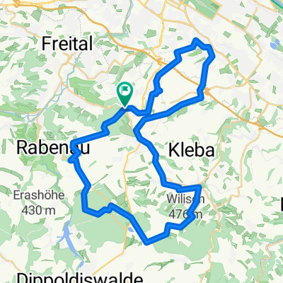
The start and finish is at the Dreifeldhalle of the municipality of Bannewitz. On the bike path of the former railway track, it goes without incline to Possendorf. Further, the route leads on the bike path to Kleincarsdorf and along the apple plantation to Kreischa up to the nursery. Advice and tours are possible during opening hours. The beehive therapy offered on-site to alleviate respiratory problems can be booked during the summer months. Through the ascent to Kautzsch and on quiet side streets with wide views of the landscape, the tour leads to Rippien. Now the view opens up over the Elbe valley above Dresden. Back in Bannewitz, there is the option to shorten the tour back to the starting point. It continues through Boderitz and the Kaitzer Höhe to the Coschütz waterworks. A tour of Dresden's largest waterworks is available via the visitor service with prior registration. Afterwards, the tour goes through Gittersee to Windberg. The local animal shelter houses many four-legged friends and other pets looking for a new home and appreciate donations. From here it is worth taking a detour to the König-Albert monument with a view over Freital. The way back to the starting point leads again via the bike path of the former Windbergbahn.
- 2 h 1 min
- Duration
- 31.6 km
- Distance
- 447 m
- Ascent
- 446 m
- Descent
- 15.7 km/h
- Avg. speed
- 361 m
- Max. altitude
Route photos


Route quality
Waytypes & surfaces along the route
Waytypes
Quiet road
4.4 km
(14 %)
Path
3.5 km
(11 %)
Surfaces
Paved
12.6 km
(40 %)
Unpaved
0.3 km
(1 %)
Asphalt
12.6 km
(40 %)
Gravel
0.3 km
(1 %)
Undefined
18.6 km
(59 %)
Route highlights
Points of interest along the route

Point of interest after 10.8 km
Baumschule Kreischa

Point of interest after 21.3 km
Wasserwerk Coschütz

Point of interest after 26.2 km
Tierheim Freital

Point of interest after 26.8 km
König-Albert-Denkmal
Continue with Bikemap
Use, edit, or download this cycling route
You would like to ride RundumTour Bannewitz 2025 or customize it for your own trip? Here is what you can do with this Bikemap route:
Free features
- Save this route as favorite or in collections
- Copy & plan your own version of this route
- Sync your route with Garmin or Wahoo
Premium features
Free trial for 3 days, or one-time payment. More about Bikemap Premium.
- Navigate this route on iOS & Android
- Export a GPX / KML file of this route
- Create your custom printout (try it for free)
- Download this route for offline navigation
Discover more Premium features.
Get Bikemap PremiumFrom our community
Other popular routes starting in Bannewitz
 Windberg-Poisenwald-Tharandt
- Distance
- 47.2 km
- Ascent
- 865 m
- Descent
- 865 m
- Location
- Bannewitz, Saxony, Germany
 MTB Tour Windberg, Heidemühle, Wilisch, Windberg CLONED FROM ROUTE 182971
- Distance
- 42.5 km
- Ascent
- 628 m
- Descent
- 662 m
- Location
- Bannewitz, Saxony, Germany
 Etapa 046C (Dresden - Děčín)
- Distance
- 91.8 km
- Ascent
- 869 m
- Descent
- 860 m
- Location
- Bannewitz, Saxony, Germany
 Südhöhe-Kaitzbachquelle und zurück
- Distance
- 9.9 km
- Ascent
- 170 m
- Descent
- 190 m
- Location
- Bannewitz, Saxony, Germany
- RundumTour Bannewitz 2025
- Distance
- 31.6 km
- Ascent
- 447 m
- Descent
- 446 m
- Location
- Bannewitz, Saxony, Germany
 Radtour Elberadweg
- Distance
- 30.6 km
- Ascent
- 26 m
- Descent
- 32 m
- Location
- Bannewitz, Saxony, Germany
 Die Autobahntour: 34 km Hügel im Dresdner Süden
- Distance
- 33.9 km
- Ascent
- 549 m
- Descent
- 548 m
- Location
- Bannewitz, Saxony, Germany
 Südhöhe - Rundfahrt
- Distance
- 53.5 km
- Ascent
- 792 m
- Descent
- 747 m
- Location
- Bannewitz, Saxony, Germany
Open it in the app