

Rund um den Kronberg
A cycling route starting in Urnäsch, Canton of Appenzell Ausserrhoden, Switzerland.
Overview
About this route
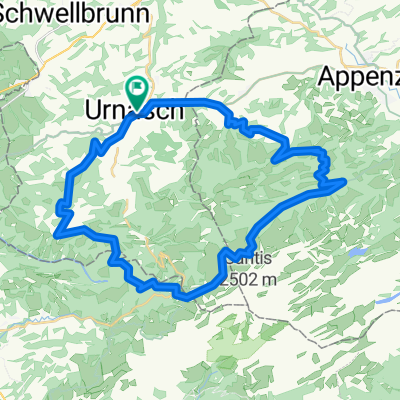
Urnäsch - Schwägalp - Weissbad - Appenzell - Gonten - Urnäsch
Great tour with views. Climb up to Schwägalp, then an 11 km descent to Weissbad.
For less experienced riders, the Appenzeller train could be used from Weissbad for the return trip to Urnäsch.
The tour involves few technical difficulties.
- -:--
- Duration
- 38.9 km
- Distance
- 737 m
- Ascent
- 737 m
- Descent
- ---
- Avg. speed
- ---
- Max. altitude
Route quality
Waytypes & surfaces along the route
Waytypes
Track
15.2 km
(39 %)
Quiet road
7 km
(18 %)
Surfaces
Paved
26.9 km
(69 %)
Unpaved
7.4 km
(19 %)
Asphalt
24.9 km
(64 %)
Gravel
6.6 km
(17 %)
Continue with Bikemap
Use, edit, or download this cycling route
You would like to ride Rund um den Kronberg or customize it for your own trip? Here is what you can do with this Bikemap route:
Free features
- Save this route as favorite or in collections
- Copy & plan your own version of this route
- Sync your route with Garmin or Wahoo
Premium features
Free trial for 3 days, or one-time payment. More about Bikemap Premium.
- Navigate this route on iOS & Android
- Export a GPX / KML file of this route
- Create your custom printout (try it for free)
- Download this route for offline navigation
Discover more Premium features.
Get Bikemap PremiumFrom our community
Other popular routes starting in Urnäsch
 Rund um Kronberg
- Distance
- 41.3 km
- Ascent
- 1,429 m
- Descent
- 1,426 m
- Location
- Urnäsch, Canton of Appenzell Ausserrhoden, Switzerland
 Rund um den Kronberg
- Distance
- 38.9 km
- Ascent
- 737 m
- Descent
- 737 m
- Location
- Urnäsch, Canton of Appenzell Ausserrhoden, Switzerland
 Zweiter Tag 1.Route
- Distance
- 92.5 km
- Ascent
- 1,338 m
- Descent
- 1,345 m
- Location
- Urnäsch, Canton of Appenzell Ausserrhoden, Switzerland
 Schwägalptour
- Distance
- 66.1 km
- Ascent
- 1,320 m
- Descent
- 1,320 m
- Location
- Urnäsch, Canton of Appenzell Ausserrhoden, Switzerland
 053_1220_Schwägalp_Hemberg_St.Peterszell
- Distance
- 53.4 km
- Ascent
- 1,218 m
- Descent
- 1,221 m
- Location
- Urnäsch, Canton of Appenzell Ausserrhoden, Switzerland
 078_1550_Urnäsch-Trogen-Altstädten
- Distance
- 77.8 km
- Ascent
- 1,438 m
- Descent
- 1,409 m
- Location
- Urnäsch, Canton of Appenzell Ausserrhoden, Switzerland
 Urnäsch,Appenzell, Ruppenpass, Eichberg, Oberriet, Buchs, Balzers, Luzisteig,, Maienfeld, Chur, Thusis
- Distance
- 124.5 km
- Ascent
- 1,462 m
- Descent
- 1,579 m
- Location
- Urnäsch, Canton of Appenzell Ausserrhoden, Switzerland
 144_1730_Urnäsch-Appenzell-Bregenz-Wittenbach
- Distance
- 143.8 km
- Ascent
- 1,335 m
- Descent
- 1,342 m
- Location
- Urnäsch, Canton of Appenzell Ausserrhoden, Switzerland
Open it in the app