Freundschafts-Tour
A cycling route starting in Lembach, Grand Est, France.
Overview
About this route
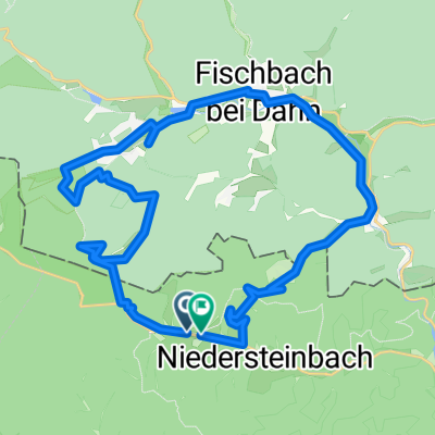
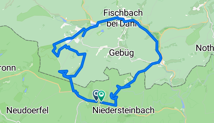
The Friendship Tour is an approximately 28.3 km round trip that starts in Obersteinbach/F and passes historic sites such as the 'Black Table', the Area 1 installation from the Cold War, and the legendary ruins of Wasigenstein Castle. The Biosphere House with its treetop path in Fischbach also invites a stopover.
- -:--
- Duration
- 30.4 km
- Distance
- 706 m
- Ascent
- 706 m
- Descent
- ---
- Avg. speed
- 425 m
- Max. altitude
Continue with Bikemap
Use, edit, or download this cycling route
You would like to ride Freundschafts-Tour or customize it for your own trip? Here is what you can do with this Bikemap route:
Free features
- Save this route as favorite or in collections
- Copy & plan your own version of this route
- Sync your route with Garmin or Wahoo
Premium features
Free trial for 3 days, or one-time payment. More about Bikemap Premium.
- Navigate this route on iOS & Android
- Export a GPX / KML file of this route
- Create your custom printout (try it for free)
- Download this route for offline navigation
Discover more Premium features.
Get Bikemap PremiumFrom our community
Other popular routes starting in Lembach
- BiosphÀrenhaus
- Distance
- 37.5 km
- Ascent
- 275 m
- Descent
- 273 m
- Location
- Lembach, Grand Est, France
- C3 Circuit transfrontalier
- Distance
- 45.9 km
- Ascent
- 383 m
- Descent
- 384 m
- Location
- Lembach, Grand Est, France
- 2012 French Tour -- Ride Day 23 -- 3 September 2012 -- Climbach -- Circle
- Distance
- 48.3 km
- Ascent
- 435 m
- Descent
- 433 m
- Location
- Lembach, Grand Est, France
- Ex - C 01 - Entre forĂȘt et route du vin â 42 km
- Distance
- 42.6 km
- Ascent
- 569 m
- Descent
- 569 m
- Location
- Lembach, Grand Est, France
- VTT - Marienbronn
- Distance
- 17.1 km
- Ascent
- 415 m
- Descent
- 418 m
- Location
- Lembach, Grand Est, France
- C1 Histoire et colombages.
- Distance
- 84.3 km
- Ascent
- 618 m
- Descent
- 618 m
- Location
- Lembach, Grand Est, France
- Freundschafts-Tour
- Distance
- 30.4 km
- Ascent
- 706 m
- Descent
- 706 m
- Location
- Lembach, Grand Est, France
- C4 A la dĂ©couverte de l'Outre-ForĂȘt
- Distance
- 77.7 km
- Ascent
- 425 m
- Descent
- 424 m
- Location
- Lembach, Grand Est, France
Open it in the app