
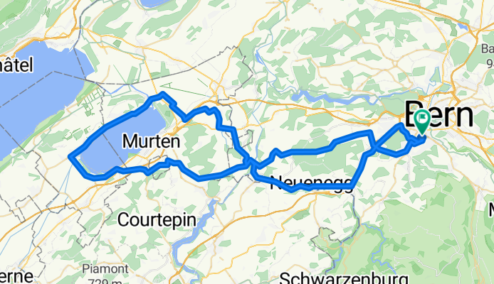
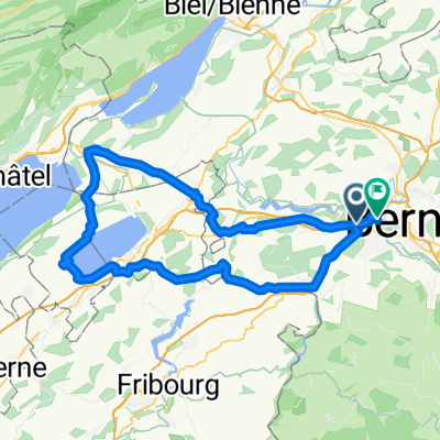
085.068 Murtensee
A cycling route starting in Köniz, Canton of Bern, Switzerland.
Overview
About this route
RR Schaller -Köniz - Niederwangen - Oberbottigen - Süri - Laupenmüli - Kriechenwil - Liebistorf - Jeuss - Salvenach - Münchenwiler - Courgevaux - Faoug - Salavaux - Vallamand Dessous - Guévaux - Môtier - Praz - Sugiez - Kerzers - Wileroltigen - Rizenbach - Wallenbuch - Kriechenwil - Laupen - Neuenegg - Thörishaus - Oberwangen - Niederwangen - Bern-Ausserholligen - RR Schaller
- 5 h 15 min
- Duration
- 85.2 km
- Distance
- 456 m
- Ascent
- 457 m
- Descent
- 16.2 km/h
- Avg. speed
- 637 m
- Max. altitude
Route quality
Waytypes & surfaces along the route
Waytypes
Road
37.5 km
(44 %)
Quiet road
18.7 km
(22 %)
Surfaces
Paved
37.5 km
(44 %)
Asphalt
37.5 km
(44 %)
Undefined
47.7 km
(56 %)
Continue with Bikemap
Use, edit, or download this cycling route
You would like to ride 085.068 Murtensee or customize it for your own trip? Here is what you can do with this Bikemap route:
Free features
- Save this route as favorite or in collections
- Copy & plan your own version of this route
- Split it into stages to create a multi-day tour
- Sync your route with Garmin or Wahoo
Premium features
Free trial for 3 days, or one-time payment. More about Bikemap Premium.
- Navigate this route on iOS & Android
- Export a GPX / KML file of this route
- Create your custom printout (try it for free)
- Download this route for offline navigation
Discover more Premium features.
Get Bikemap PremiumFrom our community
Other popular routes starting in Köniz
 Da Neue Murtenstrasse a Bühlstrasse
- Distance
- 89.1 km
- Ascent
- 640 m
- Descent
- 630 m
- Location
- Köniz, Canton of Bern, Switzerland
 Sensetour by mnh
- Distance
- 40.1 km
- Ascent
- 425 m
- Descent
- 425 m
- Location
- Köniz, Canton of Bern, Switzerland
 Hügelige Emmentalrunde
- Distance
- 147.7 km
- Ascent
- 2,029 m
- Descent
- 2,029 m
- Location
- Köniz, Canton of Bern, Switzerland
 Köniz-Bremgartenwald-Wohlensee-Wohleiberg-Köniz by mnh
- Distance
- 36.4 km
- Ascent
- 466 m
- Descent
- 465 m
- Location
- Köniz, Canton of Bern, Switzerland
 Berner Hügelweg 3 GCL links Var.1
- Distance
- 46.3 km
- Ascent
- 1,084 m
- Descent
- 1,081 m
- Location
- Köniz, Canton of Bern, Switzerland
 Emmentaler-Hogerderby
- Distance
- 127.8 km
- Ascent
- 1,615 m
- Descent
- 1,615 m
- Location
- Köniz, Canton of Bern, Switzerland
 De Dorfbachstrasse 58, Köniz a Dorfbachstrasse 60, Köniz
- Distance
- 63.5 km
- Ascent
- 1,079 m
- Descent
- 1,079 m
- Location
- Köniz, Canton of Bern, Switzerland
 Knackige Tour Oberwangen, Kleinbösingen, Mühletal und retour
- Distance
- 33.7 km
- Ascent
- 521 m
- Descent
- 456 m
- Location
- Köniz, Canton of Bern, Switzerland
Open it in the app