
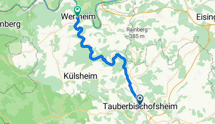
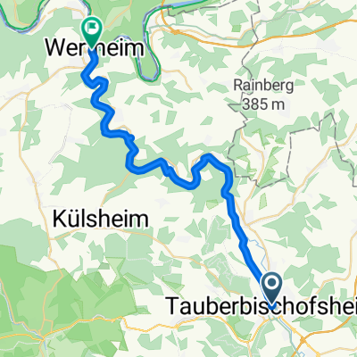
St.-Lioba-Straße nach Linke Tauberstraße
A cycling route starting in Tauberbischofsheim, Baden-Wurttemberg, Germany.
Overview
About this route
- 1 h 46 min
- Duration
- 29.3 km
- Distance
- 169 m
- Ascent
- 207 m
- Descent
- 16.5 km/h
- Avg. speed
- 195 m
- Max. altitude

Route quality
Waytypes & surfaces along the route
Waytypes
Track
17 km
(58 %)
Quiet road
6.4 km
(22 %)
Surfaces
Paved
29.3 km
(100 %)
Asphalt
23.7 km
(81 %)
Paved (undefined)
5.6 km
(19 %)
Continue with Bikemap
Use, edit, or download this cycling route
You would like to ride St.-Lioba-Straße nach Linke Tauberstraße or customize it for your own trip? Here is what you can do with this Bikemap route:
Free features
- Save this route as favorite or in collections
- Copy & plan your own version of this route
- Sync your route with Garmin or Wahoo
Premium features
Free trial for 3 days, or one-time payment. More about Bikemap Premium.
- Navigate this route on iOS & Android
- Export a GPX / KML file of this route
- Create your custom printout (try it for free)
- Download this route for offline navigation
Discover more Premium features.
Get Bikemap PremiumFrom our community
Other popular routes starting in Tauberbischofsheim
 RT 2016, 5. Etappe; TBB - Miltenberg
- Distance
- 46 km
- Ascent
- 358 m
- Descent
- 416 m
- Location
- Tauberbischofsheim, Baden-Wurttemberg, Germany
 UT 08-2023: Tauberbischofsheim - Miltenberg
- Distance
- 62.8 km
- Ascent
- 427 m
- Descent
- 476 m
- Location
- Tauberbischofsheim, Baden-Wurttemberg, Germany
 1993-2010 Taubertal Radweg
- Distance
- 76.1 km
- Ascent
- 846 m
- Descent
- 685 m
- Location
- Tauberbischofsheim, Baden-Wurttemberg, Germany
 St.-Lioba-Straße nach Linke Tauberstraße
- Distance
- 29.3 km
- Ascent
- 169 m
- Descent
- 207 m
- Location
- Tauberbischofsheim, Baden-Wurttemberg, Germany
 Tauber Main
- Distance
- 110.4 km
- Ascent
- 642 m
- Descent
- 644 m
- Location
- Tauberbischofsheim, Baden-Wurttemberg, Germany
 Lange Ausfahrt durch Taubertal
- Distance
- 40.1 km
- Ascent
- 118 m
- Descent
- 118 m
- Location
- Tauberbischofsheim, Baden-Wurttemberg, Germany
 Von Tauberbischofsheim bis Mainz
- Distance
- 181.5 km
- Ascent
- 1,119 m
- Descent
- 1,163 m
- Location
- Tauberbischofsheim, Baden-Wurttemberg, Germany
 AOK-Radtour-Tag 1
- Distance
- 56.9 km
- Ascent
- 778 m
- Descent
- 779 m
- Location
- Tauberbischofsheim, Baden-Wurttemberg, Germany
Open it in the app