

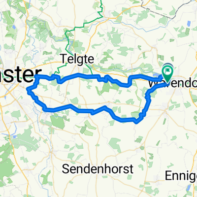
1.Mai Tour 2009
A cycling route starting in Warendorf, North Rhine-Westphalia, Germany.
Overview
About this route
Fun loop through and around Warendorf.
- -:--
- Duration
- 37.8 km
- Distance
- 56 m
- Ascent
- 55 m
- Descent
- ---
- Avg. speed
- 68 m
- Max. altitude
Route quality
Waytypes & surfaces along the route
Waytypes
Quiet road
19.6 km
(52 %)
Path
9.8 km
(26 %)
Surfaces
Paved
27.2 km
(72 %)
Unpaved
3.4 km
(9 %)
Asphalt
23 km
(61 %)
Paved (undefined)
3.8 km
(10 %)
Continue with Bikemap
Use, edit, or download this cycling route
You would like to ride 1.Mai Tour 2009 or customize it for your own trip? Here is what you can do with this Bikemap route:
Free features
- Save this route as favorite or in collections
- Copy & plan your own version of this route
- Sync your route with Garmin or Wahoo
Premium features
Free trial for 3 days, or one-time payment. More about Bikemap Premium.
- Navigate this route on iOS & Android
- Export a GPX / KML file of this route
- Create your custom printout (try it for free)
- Download this route for offline navigation
Discover more Premium features.
Get Bikemap PremiumFrom our community
Other popular routes starting in Warendorf
 Grenzgängerroute Teil 1
- Distance
- 65.1 km
- Ascent
- 79 m
- Descent
- 80 m
- Location
- Warendorf, North Rhine-Westphalia, Germany
 20 km Feierabendrunde rund um Freckenhorst
- Distance
- 20.5 km
- Ascent
- 68 m
- Descent
- 68 m
- Location
- Warendorf, North Rhine-Westphalia, Germany
 17 Warendorf-Hamm
- Distance
- 88.1 km
- Ascent
- 139 m
- Descent
- 125 m
- Location
- Warendorf, North Rhine-Westphalia, Germany
 Route in Warendorf
- Distance
- 55.8 km
- Ascent
- 181 m
- Descent
- 179 m
- Location
- Warendorf, North Rhine-Westphalia, Germany
 Everswinkel - Halle + Halle - Porta Westfalica
- Distance
- 73.5 km
- Ascent
- 342 m
- Descent
- 277 m
- Location
- Warendorf, North Rhine-Westphalia, Germany
 Warendorf - Saerbeck
- Distance
- 57.8 km
- Ascent
- 21 m
- Descent
- 33 m
- Location
- Warendorf, North Rhine-Westphalia, Germany
 MTB Runde Richtung Telgte
- Distance
- 32.9 km
- Ascent
- 266 m
- Descent
- 261 m
- Location
- Warendorf, North Rhine-Westphalia, Germany
 ne Runde von WAF nach LIP
- Distance
- 122.4 km
- Ascent
- 400 m
- Descent
- 396 m
- Location
- Warendorf, North Rhine-Westphalia, Germany
Open it in the app