
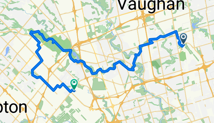
Downsview Park to Malton Via West Humber and Claireville Ranch
A cycling route starting in Concord, Ontario, Canada.
Overview
About this route
37 km bike ride from Downsview Park to Malton Via West Humber and Claireville Ranch.
- 2 h 40 min
- Duration
- 43.9 km
- Distance
- 216 m
- Ascent
- 239 m
- Descent
- 16.5 km/h
- Avg. speed
- 205 m
- Max. altitude

Route quality
Waytypes & surfaces along the route
Waytypes
Path
16.2 km
(37 %)
Quiet road
7 km
(16 %)
Surfaces
Paved
35.1 km
(80 %)
Unpaved
3.1 km
(7 %)
Asphalt
33.8 km
(77 %)
Gravel
3.1 km
(7 %)
Route highlights
Points of interest along the route
Point of interest after 26.8 km
Claireville Ranch, 3805 Queen St E, Brampton, ON L6T 0B3, (905) 794-0700, https://www.clairevilleranch.com
Point of interest after 36.6 km
Flava Pot Cuisine Restaurant 4:00 pm to 5:00 pm 700 Balmoral Dr Unit 11A, Brampton, ON L6T 1X2
Continue with Bikemap
Use, edit, or download this cycling route
You would like to ride Downsview Park to Malton Via West Humber and Claireville Ranch or customize it for your own trip? Here is what you can do with this Bikemap route:
Free features
- Save this route as favorite or in collections
- Copy & plan your own version of this route
- Sync your route with Garmin or Wahoo
Premium features
Free trial for 3 days, or one-time payment. More about Bikemap Premium.
- Navigate this route on iOS & Android
- Export a GPX / KML file of this route
- Create your custom printout (try it for free)
- Download this route for offline navigation
Discover more Premium features.
Get Bikemap PremiumFrom our community
Other popular routes starting in Concord
 Downsview Park to Carl Laidlaw Orchards Via West Humber Trail, Etobicoke Creek. Return Mount Pleasant GO
- Distance
- 53.7 km
- Ascent
- 354 m
- Descent
- 306 m
- Location
- Concord, Ontario, Canada
 Heart Lake
- Distance
- 53.2 km
- Ascent
- ---
- Descent
- ---
- Location
- Concord, Ontario, Canada
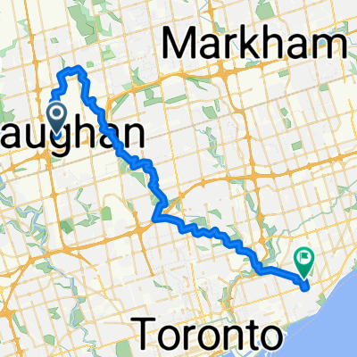 From Vaughan to Victoria Park Via BS Greenway, GRoss Lord, Earl Bales, Glendon Forest, Sunnybrook, Taylor Creek
- Distance
- 46.5 km
- Ascent
- 283 m
- Descent
- 357 m
- Location
- Concord, Ontario, Canada
 San Gabriele Place 9, Toronto to Stanley Avenue 5879-5899, Niagara Falls
- Distance
- 136 km
- Ascent
- 563 m
- Descent
- 526 m
- Location
- Concord, Ontario, Canada
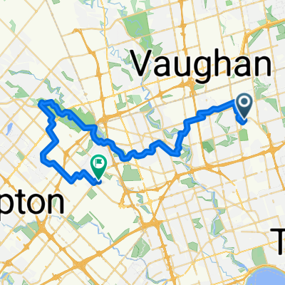 Downsview Park to Malton Via West Humber and Claireville Ranch
- Distance
- 43.9 km
- Ascent
- 216 m
- Descent
- 239 m
- Location
- Concord, Ontario, Canada
 Highcliffe Drive to Roncesvalles Avenue
- Distance
- 85.2 km
- Ascent
- 430 m
- Descent
- 503 m
- Location
- Concord, Ontario, Canada
 Kleinburg
- Distance
- 40.9 km
- Ascent
- 263 m
- Descent
- 263 m
- Location
- Concord, Ontario, Canada
 Vaughan Subway Down Humber Rver to Lakeshore, End Unon Station
- Distance
- 36.6 km
- Ascent
- 267 m
- Descent
- 267 m
- Location
- Concord, Ontario, Canada
Open it in the app