![Cluses to Cully via Thonens [ferry 18km]](/_next/static/media/contour-lines-light-small.cafd5e5d.avif)
![Cluses to Cully via Thonens [ferry 18km]](https://media.bikemap.net/routes/16946953/staticmaps/in_e4494b37-2f9a-46d8-bc18-94bf9b8238d0_694x400_bikemap-2021-3D-static.png)
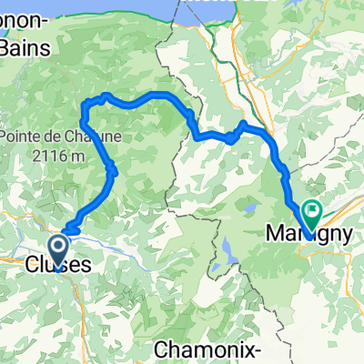
Cluses to Cully via Thonens [ferry 18km]
A cycling route starting in Cluses, Auvergne-Rhône-Alpes, France.
Overview
About this route
- 5 h 31 min
- Duration
- 87.1 km
- Distance
- 2,063 m
- Ascent
- 2,170 m
- Descent
- 15.8 km/h
- Avg. speed
- 1,168 m
- Max. altitude

Route photos
![Photo 1 of the Bikemap route "Cluses to Cully via Thonens [ferry 18km]"](https://www.bikemap.net/media/temp/routes_gallery/4b510814-05f9-4722-aaf8-b25c05cc8fd2.png "Photo 1 of the Bikemap route \"Cluses to Cully via Thonens [ferry 18km]\"")
Route quality
Waytypes & surfaces along the route
Waytypes
Cycleway
18.3 km
(21 %)
Road
9.6 km
(11 %)
Surfaces
Paved
65.3 km
(75 %)
Asphalt
65.3 km
(75 %)
Undefined
21.8 km
(25 %)
Route highlights
Points of interest along the route
Point of interest after 6.4 km
Col de Châtillon (741 m) 5.8km 256m climb 4.4% av 6.7% max
Point of interest after 20.3 km
Col des Gets 11.3km 522m climb 4.6% av 7.0% max 1164m altitude
![Highlight 3 along the Bikemap route "Cluses to Cully via Thonens [ferry 18km]"](https://www.bikemap.net/media/temp/routes_pois/a1a9991d-7c4e-4d2c-8d47-96d2113e9d50.png "Highlight 3 along the Bikemap route \"Cluses to Cully via Thonens [ferry 18km]\"")
Point of interest after 40.3 km
Les Gorges du Pont du Diable
Point of interest after 57.5 km
Ferry to Lausanne 50 min CHF 30 pp 1125, 1325, 1525 then hourly
Point of interest after 59.5 km
Château de Ripaille Former monastery, castle and gardens set on a lakeside surrounded by vineyards, with guided tours.
Point of interest after 76.3 km
Ouverture au Monde
Point of interest after 77.2 km
Palais de Rumine Renaissance-style palace with several museums including fine art, zoology and archaeology collections.
Point of interest after 77.3 km
Lausanne Cathedral Cathédrale de Lausanne Towering 1100s Gothic cathedral, known for its ornate painted portal, belfry and vibrant rose window.
Point of interest after 77.3 km
The Olympic Museum Musée Olympique Permanent exhibition on Olympic athletes, architects and others, plus a park with an athletics track.
Point of interest after 77.4 km
Feu Olympique et statue Pierre de Coubertin
Point of interest after 84.6 km
Les vignes de Lavaux
Continue with Bikemap
Use, edit, or download this cycling route
You would like to ride Cluses to Cully via Thonens [ferry 18km] or customize it for your own trip? Here is what you can do with this Bikemap route:
Free features
- Save this route as favorite or in collections
- Copy & plan your own version of this route
- Split it into stages to create a multi-day tour
- Sync your route with Garmin or Wahoo
Premium features
Free trial for 3 days, or one-time payment. More about Bikemap Premium.
- Navigate this route on iOS & Android
- Export a GPX / KML file of this route
- Create your custom printout (try it for free)
- Download this route for offline navigation
Discover more Premium features.
Get Bikemap PremiumFrom our community
Other popular routes starting in Cluses
- Cluses to Cully via Thonens [ferry 18km]
- Distance
- 87.1 km
- Ascent
- 2,063 m
- Descent
- 2,170 m
- Location
- Cluses, Auvergne-Rhône-Alpes, France
 2. Etappe Genf - Nizza
- Distance
- 91 km
- Ascent
- 2,406 m
- Descent
- 2,406 m
- Location
- Cluses, Auvergne-Rhône-Alpes, France
![Cluses to Lausanne via Thonon [ferry 20km]](https://media.bikemap.net/routes/17030836/staticmaps/in_d2dbdd77-c243-4829-8222-8e25763eee72_400x400_bikemap-2021-3D-static.png) Cluses to Lausanne via Thonon [ferry 20km]
Cluses to Lausanne via Thonon [ferry 20km]- Distance
- 87.6 km
- Ascent
- 2,076 m
- Descent
- 2,183 m
- Location
- Cluses, Auvergne-Rhône-Alpes, France
 Col du Romme, Col de la Colombiere, Col de St.-Jean-de-Sixt, Col des Aravis, Col de Megève
- Distance
- 99.1 km
- Ascent
- 2,243 m
- Descent
- 2,241 m
- Location
- Cluses, Auvergne-Rhône-Alpes, France
 GTJR6ter_Cluses-Mey_My
- Distance
- 108.3 km
- Ascent
- 2,799 m
- Descent
- 2,816 m
- Location
- Cluses, Auvergne-Rhône-Alpes, France
 Cluses-Ramaz-Encrenaz-Joux Plane-Cluses
- Distance
- 96 km
- Ascent
- 2,136 m
- Descent
- 2,136 m
- Location
- Cluses, Auvergne-Rhône-Alpes, France
 Cluses jour 2
- Distance
- 116.5 km
- Ascent
- 2,405 m
- Descent
- 2,405 m
- Location
- Cluses, Auvergne-Rhône-Alpes, France
 XX-D. Cluses - Col des Annes (Km 133)
- Distance
- 132.9 km
- Ascent
- 4,503 m
- Descent
- 3,260 m
- Location
- Cluses, Auvergne-Rhône-Alpes, France
Open it in the app