

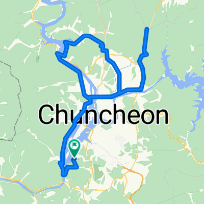
의암호 코스
A cycling route starting in Chuncheon, Gangwon-do, South Korea.
Overview
About this route
- 1 h 58 min
- Duration
- 29.3 km
- Distance
- 432 m
- Ascent
- 432 m
- Descent
- 14.8 km/h
- Avg. speed
- 137 m
- Max. altitude

Route quality
Waytypes & surfaces along the route
Waytypes
Cycleway
22.2 km
(76 %)
Quiet road
4.7 km
(16 %)
Surfaces
Paved
24.9 km
(85 %)
Asphalt
23.1 km
(79 %)
Wood
1.8 km
(6 %)
Undefined
4.4 km
(15 %)
Continue with Bikemap
Use, edit, or download this cycling route
You would like to ride 의암호 코스 or customize it for your own trip? Here is what you can do with this Bikemap route:
Free features
- Save this route as favorite or in collections
- Copy & plan your own version of this route
- Sync your route with Garmin or Wahoo
Premium features
Free trial for 3 days, or one-time payment. More about Bikemap Premium.
- Navigate this route on iOS & Android
- Export a GPX / KML file of this route
- Create your custom printout (try it for free)
- Download this route for offline navigation
Discover more Premium features.
Get Bikemap PremiumFrom our community
Other popular routes starting in Chuncheon
 후평동 825-6 ~ 홍제동 111-7
- Distance
- 316.3 km
- Ascent
- 5,493 m
- Descent
- 5,569 m
- Location
- Chuncheon, Gangwon-do, South Korea
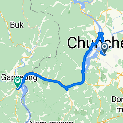 중앙로2가 ~ 가평읍 603-2
- Distance
- 39.5 km
- Ascent
- 157 m
- Descent
- 206 m
- Location
- Chuncheon, Gangwon-do, South Korea
 춘천역 - 당산역
- Distance
- 127.7 km
- Ascent
- 1,449 m
- Descent
- 1,504 m
- Location
- Chuncheon, Gangwon-do, South Korea
 비앙키 춘천 메디오폰도 2025
- Distance
- 82.6 km
- Ascent
- 1,045 m
- Descent
- 1,058 m
- Location
- Chuncheon, Gangwon-do, South Korea
 근화동, 춘천시에서 근화동, 춘천시까지
- Distance
- 30.2 km
- Ascent
- 151 m
- Descent
- 146 m
- Location
- Chuncheon, Gangwon-do, South Korea
 의암호 코스
- Distance
- 29.3 km
- Ascent
- 432 m
- Descent
- 432 m
- Location
- Chuncheon, Gangwon-do, South Korea
 춘천-배후령-하나로 간동면-파로호-화천읍-부다리-하나로 고탄리-세미고개-춘천
- Distance
- 84.4 km
- Ascent
- 1,874 m
- Descent
- 1,870 m
- Location
- Chuncheon, Gangwon-do, South Korea
 중도상하중도
- Distance
- 27.8 km
- Ascent
- 68 m
- Descent
- 76 m
- Location
- Chuncheon, Gangwon-do, South Korea
Open it in the app