
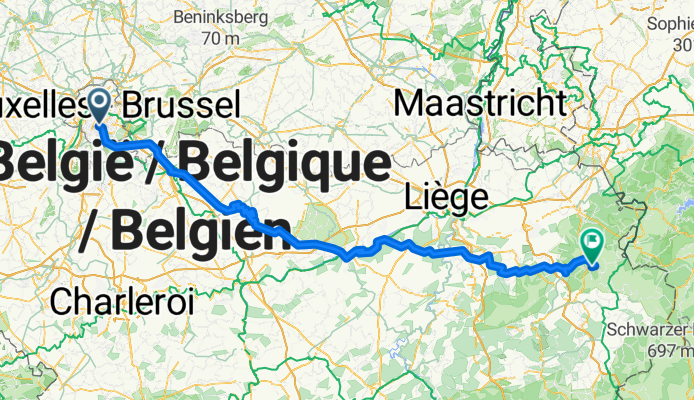
Navodila za pot od točke Avenue Montjoie 35, Uccle do točke Signal de Botrange, Waimes - Navodila za pot od točke Avenue Montjoie 35, Uccle do točke Signal d...
A cycling route starting in Drogenbos, Flemish Region, Belgium.
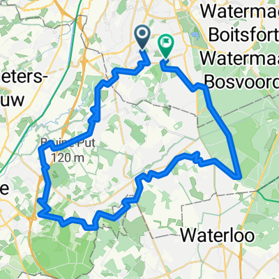
Overview
About this route
Converted from a KML file KML2GPX.COM - This is track no: 1
- -:--
- Duration
- 217.2 km
- Distance
- 2,396 m
- Ascent
- 1,820 m
- Descent
- ---
- Avg. speed
- 695 m
- Max. altitude

Continue with Bikemap
Use, edit, or download this cycling route
You would like to ride Navodila za pot od točke Avenue Montjoie 35, Uccle do točke Signal de Botrange, Waimes - Navodila za pot od točke Avenue Montjoie 35, Uccle do točke Signal d... or customize it for your own trip? Here is what you can do with this Bikemap route:
Free features
- Save this route as favorite or in collections
- Copy & plan your own version of this route
- Split it into stages to create a multi-day tour
- Sync your route with Garmin or Wahoo
Premium features
Free trial for 3 days, or one-time payment. More about Bikemap Premium.
- Navigate this route on iOS & Android
- Export a GPX / KML file of this route
- Create your custom printout (try it for free)
- Download this route for offline navigation
Discover more Premium features.
Get Bikemap PremiumFrom our community
Other popular routes starting in Drogenbos
 01: Brussels – Wavre (DEVELOPED_WITH_SIGNS) - 02: Wavre – Namur (DEVELOPED_WITH_SIGNS) - 03: Namur – Dinant (DEVELOPED_WITH_SIGNS) - 04: Dinant – Marche-en-F...
- Distance
- 726.7 km
- Ascent
- 636 m
- Descent
- 612 m
- Location
- Drogenbos, Flemish Region, Belgium
 BBB club ride
- Distance
- 93.4 km
- Ascent
- 664 m
- Descent
- 663 m
- Location
- Drogenbos, Flemish Region, Belgium
 Brussels - Tubize - Trouee d'Arenberg - Mons-en-Pevele - Pogacar's fall - carrefour l'arbre - Roubaix
- Distance
- 164 km
- Ascent
- 542 m
- Descent
- 617 m
- Location
- Drogenbos, Flemish Region, Belgium
 Bruxelles-Liernu
- Distance
- 128.8 km
- Ascent
- 362 m
- Descent
- 406 m
- Location
- Drogenbos, Flemish Region, Belgium
 Promenade verte 4
- Distance
- 34.3 km
- Ascent
- 192 m
- Descent
- 192 m
- Location
- Drogenbos, Flemish Region, Belgium
 Brussels - Tubize - Trouee d'Arenberg
- Distance
- 166.6 km
- Ascent
- 545 m
- Descent
- 621 m
- Location
- Drogenbos, Flemish Region, Belgium
 Depart-JLM-Uccle-40km-Proposal1
- Distance
- 40.6 km
- Ascent
- 349 m
- Descent
- 364 m
- Location
- Drogenbos, Flemish Region, Belgium
 Grand'Route, Drogenbos à Hellestraat, Beersel
- Distance
- 14.6 km
- Ascent
- 69 m
- Descent
- 85 m
- Location
- Drogenbos, Flemish Region, Belgium
Open it in the app