
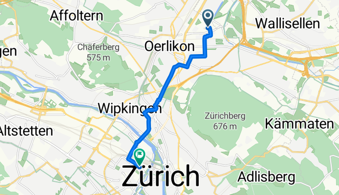
Route zu Open Ride
A cycling route starting in Zürich (Kreis 12) / Saatlen, Canton of Zurich, Switzerland.
Overview
About this route
- 22 min
- Duration
- 6.6 km
- Distance
- 68 m
- Ascent
- 85 m
- Descent
- 18.1 km/h
- Avg. speed
- 482 m
- Max. altitude

Route quality
Waytypes & surfaces along the route
Waytypes
Quiet road
2.8 km
(42 %)
Road
2.4 km
(37 %)
Surfaces
Paved
6.6 km
(100 %)
Asphalt
6.6 km
(100 %)
Continue with Bikemap
Use, edit, or download this cycling route
You would like to ride Route zu Open Ride or customize it for your own trip? Here is what you can do with this Bikemap route:
Free features
- Save this route as favorite or in collections
- Copy & plan your own version of this route
- Sync your route with Garmin or Wahoo
Premium features
Free trial for 3 days, or one-time payment. More about Bikemap Premium.
- Navigate this route on iOS & Android
- Export a GPX / KML file of this route
- Create your custom printout (try it for free)
- Download this route for offline navigation
Discover more Premium features.
Get Bikemap PremiumFrom our community
Other popular routes starting in Zürich (Kreis 12) / Saatlen
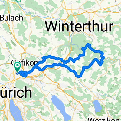 Oerlikon_Kyburg
- Distance
- 55.5 km
- Ascent
- 579 m
- Descent
- 581 m
- Location
- Zürich (Kreis 12) / Saatlen, Canton of Zurich, Switzerland
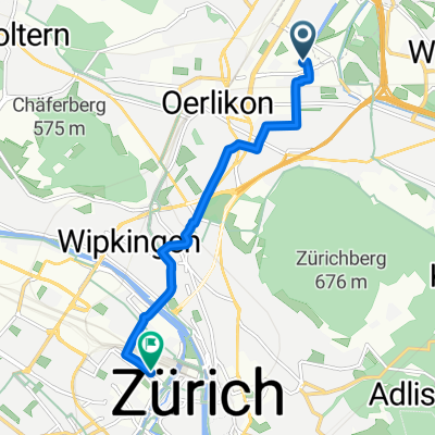
 zurUBS_viaHardbrücke
- Distance
- 7.4 km
- Ascent
- 80 m
- Descent
- 103 m
- Location
- Zürich (Kreis 12) / Saatlen, Canton of Zurich, Switzerland
 Route zu Open Ride
- Distance
- 6.6 km
- Ascent
- 68 m
- Descent
- 85 m
- Location
- Zürich (Kreis 12) / Saatlen, Canton of Zurich, Switzerland
 60km - ZH Nord - Pfäffikersee - Greifensee
- Distance
- 58.8 km
- Ascent
- 367 m
- Descent
- 366 m
- Location
- Zürich (Kreis 12) / Saatlen, Canton of Zurich, Switzerland
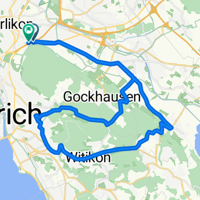 Schwamendingen-Fallanden-Pfaffhausen-Witikon-Fluntern-Dubendorf
- Distance
- 28.2 km
- Ascent
- 425 m
- Descent
- 428 m
- Location
- Zürich (Kreis 12) / Saatlen, Canton of Zurich, Switzerland
 Bachtel
- Distance
- 107.9 km
- Ascent
- 1,461 m
- Descent
- 1,464 m
- Location
- Zürich (Kreis 12) / Saatlen, Canton of Zurich, Switzerland
 Breiter-Greifen
- Distance
- 46 km
- Ascent
- 184 m
- Descent
- 184 m
- Location
- Zürich (Kreis 12) / Saatlen, Canton of Zurich, Switzerland
 home-hochwacht (860 müM)
- Distance
- 25.7 km
- Ascent
- 551 m
- Descent
- 135 m
- Location
- Zürich (Kreis 12) / Saatlen, Canton of Zurich, Switzerland
Open it in the app