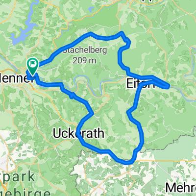
Pfannkuchenmühlen-Route
A cycling route starting in Hennef (Sieg), North Rhine-Westphalia, Germany.
Overview
About this route
- -:--
- Duration
- 47.2 km
- Distance
- 485 m
- Ascent
- 494 m
- Descent
- ---
- Avg. speed
- 215 m
- Max. altitude
Route quality
Waytypes & surfaces along the route
Waytypes
Quiet road
9 km
(19 %)
Path
8.5 km
(18 %)
Surfaces
Paved
32.1 km
(68 %)
Unpaved
7.1 km
(15 %)
Asphalt
31.6 km
(67 %)
Loose gravel
2.8 km
(6 %)
Continue with Bikemap
Use, edit, or download this cycling route
You would like to ride Pfannkuchenmühlen-Route or customize it for your own trip? Here is what you can do with this Bikemap route:
Free features
- Save this route as favorite or in collections
- Copy & plan your own version of this route
- Sync your route with Garmin or Wahoo
Premium features
Free trial for 3 days, or one-time payment. More about Bikemap Premium.
- Navigate this route on iOS & Android
- Export a GPX / KML file of this route
- Create your custom printout (try it for free)
- Download this route for offline navigation
Discover more Premium features.
Get Bikemap PremiumFrom our community
Other popular routes starting in Hennef (Sieg)
Große Tour um Waldbröl- Distance
- 102.2 km
- Ascent
- 569 m
- Descent
- 576 m
- Location
- Hennef (Sieg), North Rhine-Westphalia, Germany
Rechts und Links der Sieg- Distance
- 48.8 km
- Ascent
- 552 m
- Descent
- 454 m
- Location
- Hennef (Sieg), North Rhine-Westphalia, Germany
Hennef Rhein Sieg Hennef CLONED FROM ROUTE 417398- Distance
- 48.9 km
- Ascent
- 261 m
- Descent
- 261 m
- Location
- Hennef (Sieg), North Rhine-Westphalia, Germany
Pfannkuchenmühlen-Route- Distance
- 47.2 km
- Ascent
- 485 m
- Descent
- 494 m
- Location
- Hennef (Sieg), North Rhine-Westphalia, Germany
RTF Seelscheid- Distance
- 79.8 km
- Ascent
- 944 m
- Descent
- 939 m
- Location
- Hennef (Sieg), North Rhine-Westphalia, Germany
Hennef Rhein Sieg Hennef- Distance
- 48.9 km
- Ascent
- 299 m
- Descent
- 327 m
- Location
- Hennef (Sieg), North Rhine-Westphalia, Germany
Königswinter Test- Distance
- 62.4 km
- Ascent
- 414 m
- Descent
- 414 m
- Location
- Hennef (Sieg), North Rhine-Westphalia, Germany
Hanf-/Mehr-/Holz-/Saynbach- Distance
- 89.4 km
- Ascent
- 1,449 m
- Descent
- 1,447 m
- Location
- Hennef (Sieg), North Rhine-Westphalia, Germany
Open it in the app

