
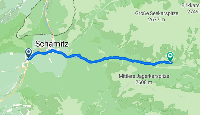
Gießenbach - Isarursprung
A cycling route starting in Scharnitz, Tyrol, Austria.
Overview
About this route
- 1 h 28 min
- Duration
- 15.3 km
- Distance
- 272 m
- Ascent
- 113 m
- Descent
- 10.4 km/h
- Avg. speed
- 1,168 m
- Max. altitude

Route photos


Route quality
Waytypes & surfaces along the route
Waytypes
Track
10.6 km
(70 %)
Quiet road
2.4 km
(16 %)
Surfaces
Paved
2.5 km
(16 %)
Unpaved
11.9 km
(78 %)
Gravel
9.9 km
(65 %)
Asphalt
2.5 km
(16 %)
Continue with Bikemap
Use, edit, or download this cycling route
You would like to ride Gießenbach - Isarursprung or customize it for your own trip? Here is what you can do with this Bikemap route:
Free features
- Save this route as favorite or in collections
- Copy & plan your own version of this route
- Sync your route with Garmin or Wahoo
Premium features
Free trial for 3 days, or one-time payment. More about Bikemap Premium.
- Navigate this route on iOS & Android
- Export a GPX / KML file of this route
- Create your custom printout (try it for free)
- Download this route for offline navigation
Discover more Premium features.
Get Bikemap PremiumFrom our community
Other popular routes starting in Scharnitz
 MiWA>Verona
- Distance
- 486.2 km
- Ascent
- 2,568 m
- Descent
- 3,507 m
- Location
- Scharnitz, Tyrol, Austria
 Neuried zum Karwendelhaus und zurück
- Distance
- 248.6 km
- Ascent
- 3,146 m
- Descent
- 3,146 m
- Location
- Scharnitz, Tyrol, Austria
 Pfeishütte
- Distance
- 20.8 km
- Ascent
- 1,350 m
- Descent
- 448 m
- Location
- Scharnitz, Tyrol, Austria
 Oberbrunnalm / Möslalm
- Distance
- 29.3 km
- Ascent
- 762 m
- Descent
- 763 m
- Location
- Scharnitz, Tyrol, Austria
 Möslalm
- Distance
- 24.7 km
- Ascent
- 447 m
- Descent
- 447 m
- Location
- Scharnitz, Tyrol, Austria
 Gießenbach - Pfeishütte
- Distance
- 21.9 km
- Ascent
- 1,338 m
- Descent
- 446 m
- Location
- Scharnitz, Tyrol, Austria
 cbm MTB-Tour Falkenhütte
- Distance
- 25.5 km
- Ascent
- 1,367 m
- Descent
- 575 m
- Location
- Scharnitz, Tyrol, Austria
 Karwendeltal bis Karwendelhaus
- Distance
- 35.5 km
- Ascent
- 822 m
- Descent
- 822 m
- Location
- Scharnitz, Tyrol, Austria
Open it in the app