
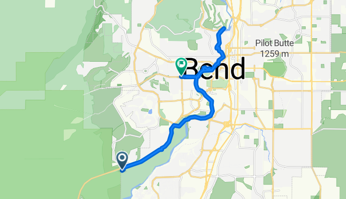
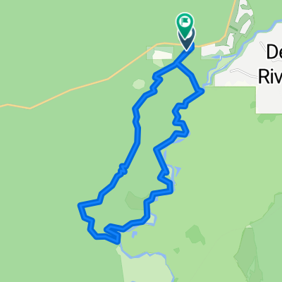
Entrada Loop, Bend to NW Galveston Ave, Bend
A cycling route starting in Deschutes River Woods, Oregon, United States.
Overview
About this route
- 1 h 18 min
- Duration
- 14.6 km
- Distance
- 28 m
- Ascent
- 92 m
- Descent
- 11.3 km/h
- Avg. speed
- 1,177 m
- Max. altitude

Route photos


Route quality
Waytypes & surfaces along the route
Waytypes
Cycleway
9.7 km
(66 %)
Path
1.6 km
(11 %)
Surfaces
Paved
6.4 km
(44 %)
Unpaved
1.9 km
(13 %)
Asphalt
5.6 km
(38 %)
Gravel
1.9 km
(13 %)
Continue with Bikemap
Use, edit, or download this cycling route
You would like to ride Entrada Loop, Bend to NW Galveston Ave, Bend or customize it for your own trip? Here is what you can do with this Bikemap route:
Free features
- Save this route as favorite or in collections
- Copy & plan your own version of this route
- Sync your route with Garmin or Wahoo
Premium features
Free trial for 3 days, or one-time payment. More about Bikemap Premium.
- Navigate this route on iOS & Android
- Export a GPX / KML file of this route
- Create your custom printout (try it for free)
- Download this route for offline navigation
Discover more Premium features.
Get Bikemap PremiumFrom our community
Other popular routes starting in Deschutes River Woods
 Easter Spin
- Distance
- 86.8 km
- Ascent
- 427 m
- Descent
- 427 m
- Location
- Deschutes River Woods, Oregon, United States
- Entrada Loop, Bend to NW Galveston Ave, Bend
- Distance
- 14.6 km
- Ascent
- 28 m
- Descent
- 92 m
- Location
- Deschutes River Woods, Oregon, United States
 Bend prologo
- Distance
- 4.1 km
- Ascent
- 51 m
- Descent
- 48 m
- Location
- Deschutes River Woods, Oregon, United States
 Bend to Klamath Falls
- Distance
- 325.7 km
- Ascent
- 2,111 m
- Descent
- 1,995 m
- Location
- Deschutes River Woods, Oregon, United States
 REGULAR RIDE
- Distance
- 24.1 km
- Ascent
- 165 m
- Descent
- 165 m
- Location
- Deschutes River Woods, Oregon, United States
3122®
Deschutes River Woods Cycling- Distance
- 20.3 km
- Ascent
- 169 m
- Descent
- 150 m
- Location
- Deschutes River Woods, Oregon, United States
 #2 south route
- Distance
- 20.2 km
- Ascent
- 74 m
- Descent
- 74 m
- Location
- Deschutes River Woods, Oregon, United States
 Tight Alright Delight variation
- Distance
- 52.5 km
- Ascent
- 585 m
- Descent
- 585 m
- Location
- Deschutes River Woods, Oregon, United States
Open it in the app