

Jaklofsky bicigeľ 2014
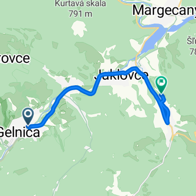
A cycling route starting in Gelnica, Košice Region, Slovakia.
Overview
About this route
Compared to the 2013 course, the following changes have been made:
-
The start is in the opposite direction to the way riders reached the finish last year; after a short asphalt climb, the course turns right onto a meadow. From the meadow, it descends over a drainage channel (beware, here you must dismount and carry your bike over an approximately 2 m wide and 0.5 m deep channel) between gardens and houses back to Jaklovce, then with an 'S' bend joins the "old course";
-
At the descent from Šibený vrch, the course turns left and with a gentle climb enters the forest, then follows a comfortable mild descent on a forest path and be careful, upon exiting the forest it sharply turns right and climbs steeply. The course continues along the edge of the forest, continuously climbing until it emerges onto a meadow at the spot where it recently entered the forest. It continues left across the meadow towards the cross, crosses the main road and continues as in 2013;
- -:--
- Duration
- 25.3 km
- Distance
- 891 m
- Ascent
- 891 m
- Descent
- ---
- Avg. speed
- ---
- Max. altitude
Route quality
Waytypes & surfaces along the route
Waytypes
Track
21.8 km
(86 %)
Quiet road
3.3 km
(13 %)
Access road
0.3 km
(1 %)
Surfaces
Paved
0.8 km
(3 %)
Unpaved
21.3 km
(84 %)
Unpaved (undefined)
11.6 km
(46 %)
Ground
5.6 km
(22 %)
Route highlights
Points of interest along the route
Point of interest after 19.1 km
Občerstvovacia stanica - tekutiny (voda, jonťák, pivo, víno :-)
Continue with Bikemap
Use, edit, or download this cycling route
You would like to ride Jaklofsky bicigeľ 2014 or customize it for your own trip? Here is what you can do with this Bikemap route:
Free features
- Save this route as favorite or in collections
- Copy & plan your own version of this route
- Sync your route with Garmin or Wahoo
Premium features
Free trial for 3 days, or one-time payment. More about Bikemap Premium.
- Navigate this route on iOS & Android
- Export a GPX / KML file of this route
- Create your custom printout (try it for free)
- Download this route for offline navigation
Discover more Premium features.
Get Bikemap PremiumFrom our community
Other popular routes starting in Gelnica
 Okolo Ružína
- Distance
- 44.7 km
- Ascent
- 948 m
- Descent
- 953 m
- Location
- Gelnica, Košice Region, Slovakia
 Prakovce- Polianka- Prakovce
- Distance
- 17.1 km
- Ascent
- 634 m
- Descent
- 634 m
- Location
- Gelnica, Košice Region, Slovakia
 Palenčáreň 2015 "dlhá"
- Distance
- 63.4 km
- Ascent
- 1,425 m
- Descent
- 1,425 m
- Location
- Gelnica, Košice Region, Slovakia
 Mníšek nad Hnilcom-Úhorná-Úhornianske sedlo-sedlo medzi Bielimi Skalami a Hekerovou- Stará Voda- Mníšek nad Hnilcom
- Distance
- 47.8 km
- Ascent
- 982 m
- Descent
- 974 m
- Location
- Gelnica, Košice Region, Slovakia
 My favorite
- Distance
- 16 km
- Ascent
- 808 m
- Descent
- 803 m
- Location
- Gelnica, Košice Region, Slovakia
 Palenčáreň 2015 "krátka"
- Distance
- 31.9 km
- Ascent
- 787 m
- Descent
- 787 m
- Location
- Gelnica, Košice Region, Slovakia
 Ružín
Ružín- Distance
- 47.2 km
- Ascent
- 609 m
- Descent
- 609 m
- Location
- Gelnica, Košice Region, Slovakia
 Gelnica- Jaklovce- V. Folkmar- v.n. Jaklovce
- Distance
- 8.9 km
- Ascent
- 117 m
- Descent
- 106 m
- Location
- Gelnica, Košice Region, Slovakia
Open it in the app